Monday, September 23, 2013

33. Treasure County


Treasure County was one of the counties formed during a ten-year period when land developers went crazy.  From 1909 through 1919, twenty-two of Montana's fifty-six counties were created, seven of them, including Treasure County, in 1919.  So many counties were formed in 1919 in anticipation of a push-back by state leaders who felt that too many counties had been formed under the lax laws in place during the 1909-1919 period.  With new laws in place, only six counties were formed after 1919.

Under the laws enacted in 1919, Treasure County would probably not have been formed, but created it was, and the 1920 US Census showed a total county population of 1,990, the highest count ever for this small piece of Montana real estate (979 square miles) with less than 1 person per square mile.  Only three Montana counties are smaller than Treasure in area (Silver Bow, 1; Deer Lodge, 30; and Wibaux, 52), and only Petroleum County, 55, is smaller in population.  The land for Treasure County came from Rosebud County, 29, which borders Treasure on both the north and the east.

Prior to 1906, much of the land of Treasure County was part of the sprawling Crow Indian Reservation, but in that year, the US Government reduced the size of the Reservation, moving its eastern boundary west to its present location.  This opened the land to white settlement, and in no time, The Flying E cattle ranch was formed, managed by Charlie J. Hysham.  The Flying E had thousands of head of cattle, and in order to supply the ranch, the Northern Pacific Railroad built a siding.  The town of Hysham grew up around this siding, and when the county was formed, Hysham became the County Seat.  To this day it is the only incorporated town in the county, with a 2010 population of 312.

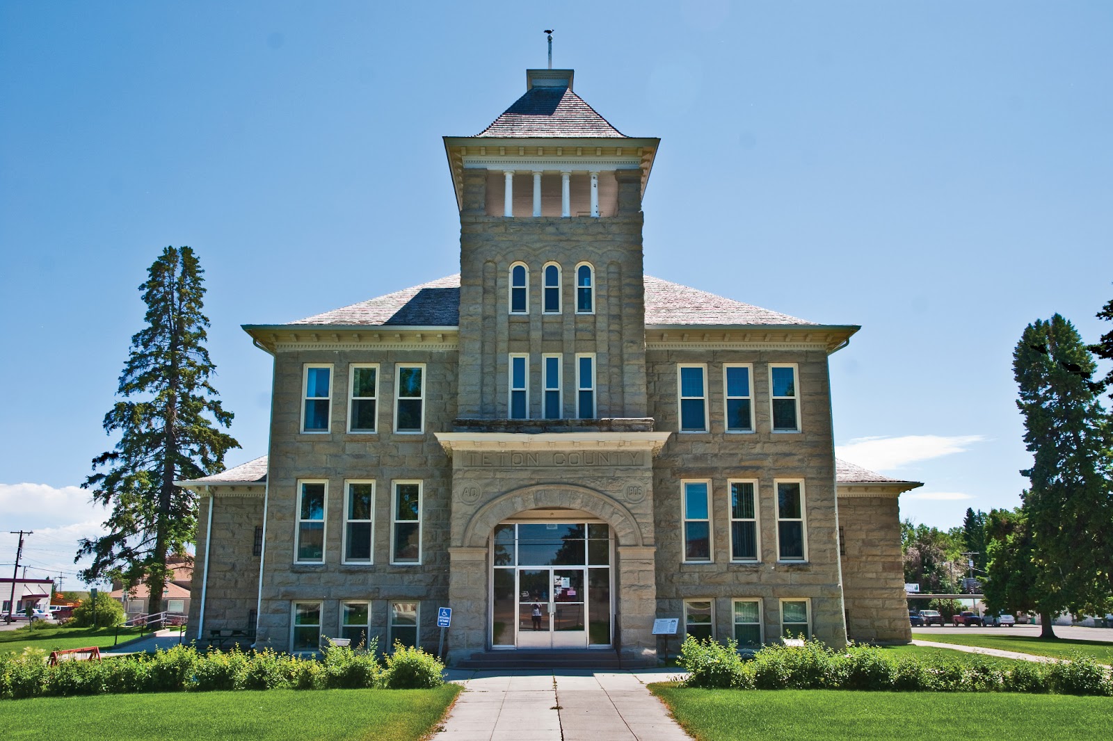
The Treasure County Courthouse, Hysham Montana
Note the map of the county done in contrasting brick

Of particular note in Hysham is the Yucca Theatre, built in 1931 by brothers David and Jim Manning.  David Manning was not just a theatre owner, but a businessman, civic leader/booster, and politician.  He was partially responsible for the city's swimming pool and water system, having improved area irrigation by building two dams in the region.  He served in the Montana Legislature for fifty-two consecutive years (1933-1985) where he promoted rural electrification and highway construction, both vital to remote rural communities like Treasure County.


 The Yucca Theatre, Hysham Montana

Next door to the Yucca Theatre are a series of statues, my favorite ones in the entire state.  I especially love the fact that Sacajawea is pointing out the wooly mammoth and the saber tooth tiger to Lewis and Clark who came through this area on their exploratory tour of the new Louisiana Purchase.


Lewis (or is it Clark) with a Saber Tooth Tiger and a Wooly Mammoth
Next door to the Yucca Theatre, Hysham Montana

As can be expected, Agriculture is the largest industry in Treasure County, with almost 51% of the county's male population involved in agriculture, forestry, fishing and hunting.  The average size of a farm or ranch in the county is 5,277 acres, and the average value of products sold per farm is $170,108.  Livestock, poultry and their products make up over 75% of the total agricultural market value.

Education comes in second employing 6.7% of males, and construction and public administration are tied in third place with 6.3% each.  Among women, education is the largest source of employment, with 21% of women working in the schools, and 15.3% work in public administration.  Like the rest of Montana, Treasure County is overwhelmingly "white," with 92.8 claiming a "white" racial background, and 3.5% claiming "Hispanic."   Again, mirroring the state as a whole, the largest reported "first ancestry" is German, with 29%, and Norwegian second at 14%.  97.8% of Treasure County residents report speaking English at home. 


Early pioneer history is always a fun topic for research, and today's researchers are fortunate to have Tales of Treasure County available on-line.  One early pioneer, a Scotsman named Robert Grierson, wrote his family in Scotland, describing conditions in what would become Treasure County.

 "I considered it good land though not black and the amount of bottom land is small compared with the big extent of grassland around. This part of Montana grows grain without irrigation. This country is on the sandstone and coal formation no gold on it. As to objections the insects are pretty bad and next to that horse stealing by straggling Indians is too common. I most decidedly think this is the best of the United States to go to and now [March] is the proper time as far as the climate affects the production of corn, watermelons, pumpkins and such like. It is not a smooth, bare plain but river bottoms for farming sheltered with grassy hills that afford lots of free pasturage for stock. And another advantage is the construction of the Northern Pacific Railroad. Another advantage, this is the center of grazing grounds of the great buffalo."
 Apparently his letters convinced his brother Donald to bring his family to Montana. Further reading in Tales of Treasure County brought this story to my attention:  the attempt by residents in the Pease Bottom area to secure postal service: 

Having no post office equipment of their own, the citizens of Junction City decided they needed that of the Etchetah Post Office. With the aid of the stage driver, Wiley King, Guy's Post Office was loaded one time while Guy was away and taken to Junction. It was returned, however, when Guy impressed the Junction residents of the probable consequences resulting from the theft of a United States Post Office.


And while we're thinking of postal service, one of the unincorporated areas in Treasure County, Sanders, has its own zip code, 59076, even though its on-again, off-again post office first opened in 1904 and finally closed in 1994.  Sanders is situated on the Yellowstone River and got its start as a place where the Northern Pacific locomotives could get the water they needed for steam generation.

Treasure County today is crossed west to east by the Yellowstone River, the Burlington Northern Santa Fe Railroad (successor to the original Northern Pacific), and Interstate Highway 94, itself successor to US Highway 10, and the original Yellowstone Trail.
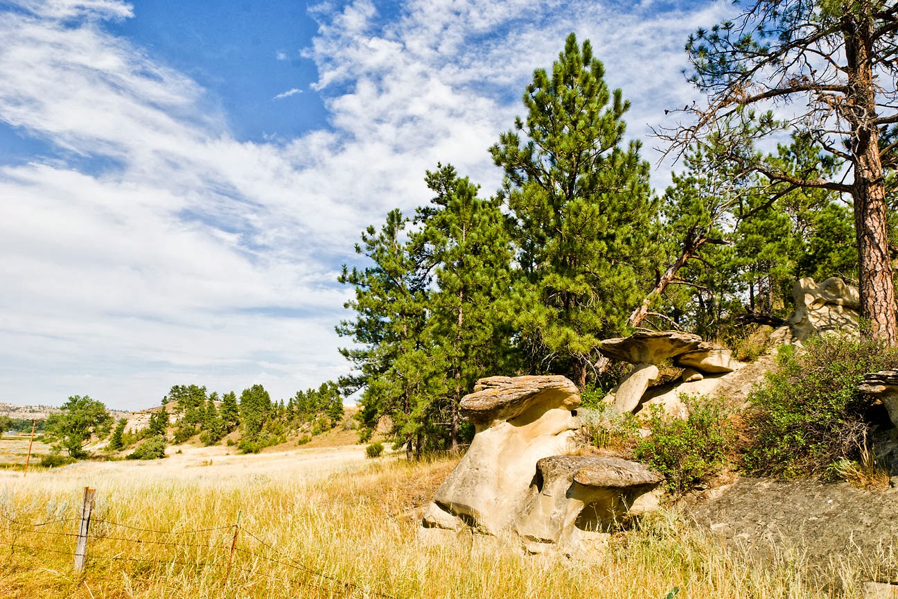
Treasure County Landscape
Southwest of Hysham


While Treasure County itself does not seem to have its own website (the Treasure County Health Department does, though), the Hysham Chamber of Commerce has a site that can be found at http://hysham.org/

Saturday, September 21, 2013

32. Stillwater County

Stillwater County was created on March 24, 1913 with land taken from its neighbors, Carbon (10) to the south, Sweet Grass (40) to the west and Yellowstone (3) to the east.  It is named for a very swift flowing stream, the Stillwater River, that flows in a northeasterly direction from its source high in the Absaroka-Beartooth Wilderness to its confluence with the Yellowstone near the town of Columbus, Stillwater County's Seat.  Jim Annin, writing in the Columbus News in 1916, retells a lovely legend about how such a torrent would be named Stillwater.  His story was printed in volume two of the collection of Stillwater County histories, They Gazed on the Beartooths.

Today, according to the 2013 US Census estimate, 9,318 people call Stillwater County home.  This is the highest population in the county's hundred year history.  The 1920 Census counted 7,630 people and this number dropped every decade (with the exception of a 2% increase shown by the 1960 Census) until 1980, when the population showed a significant (20.9%) increase over the previous count, and each Census enumeration since has continued to climb.  My best guess would be that the completion of Interstate 90 has allowed Stillwater County to grow as a bedroom community for its large neighbor to the east, Yellowstone County (3), Montana's most populous and busiest county.  In-county growth was also helped by the establishment of the Stillwater Mine near Nye in the late 1970s.

The county covers 1,805 square miles (of which 10 square miles are water).  The landscape is mostly rolling farm land that drops from the Beartooth Mountains in the south to the Yellowstone River Valley which divides the county in half as it flows toward the north-east across Montana.  North of the Yellowstone, the county is mostly dry ranchland.  Wikipedia lists 78 lakes and two reservoirs in the county, ranging in elevation from over 10,000 feet to just over 3,900 feet.  Park City, near the Yellowstone County line is probably the lowest town in the county, lying just one foot below 3,400 feet.

The Stillwater County Courthouse
Columbus, Montana


At the time of county formation, the local folk chose Columbus as their seat.  Today Columbus is the largest community in Stillwater County, with a 2012  estimated population of 1,942.  It is also about as central a location as can be found in the county, thus making it an appropriate site for local government.  The people of Stillwater County tried several times to get their own county established, first in 1907 when they proposed Roosevelt County to the state legislature.  Due to the opposition from Yellowstone and Carbon Counties primarily, that proposal failed.  As did a second attempt in 1909 and a third in 1911.  (Note:  Roosevelt County (17), eventually came into being, but in a completely different part of the state.)  But the times were changing, and a new law was introduced allowing the residents of an area to request county-status.  This was the turning point, and over the next ten years twenty-two counties were formed, including Stillwater.  Still, it is amusing to read some of the charges brought up against dividing the existing counties.  Many of these are recorded in They Gazed on the Beartooths in the section titled:  Stillwater County--A Commonwealth in the Embryo.

Occident Flour Elevator, Reed Point, Montana

On the western edge of Stillwater County lies the town of Reed Point.  The county line dividing Stillwater and Sweet Grass (40) counties is approximately two miles west of Reed Point.  This town of less than 200 people (185 in the 2000 Census) made a name for itself during Montana's Centennial Year, 1989.  As a response to the Montana Great Centennial Cattle Drive (see 23 Musselshell County), the people of Reed Point decided to host a fund raiser of their own, the Great Montana Sheep Drive.  Originally dreamt up as a spoof, but with the goal of raising funds for the town's library, the Sheep Drive succeeded beyond anyone's wildest imagining.  (I know, I was there.)  So many people showed up to watch the "running of the sheep," that the Montana Highway Patrol gave up and allowed people to park alongside Interstate 90.  There was simply no room in town to handle the cars.  There was hardly enough room on the town's streets for the 10,000 visitors who showed up.  This crazy joke has now been going on for twenty-five years, as each year Reed Point hosts one of Montana's largest Labor Day Weekend events.

Countryside south of Reed Point, showing the effects of the wildfires of 2004, 2006 and 2010


In southwestern Stillwater County lies the town of Nye.  Nye is the home of the Stillwater Mining Company, the only US producer of palladium and platinum.  Early day miners sought copper, nickel and chromium in the hills around Nye, but in the early 1970s, geologists working for the Johns-Manville Corporation discovered a band of palladium and platinum in what they named the J-M Reef.  Working together with Chevron, USA, Manville opened up the first underground mine in 1986, and in 1992 the two companies formed Stillwater Mining, with each parent company owning 50% of the new venture.   In addition to their mining operations at Nye and near Big Timber (Sweet Grass County, 40), Stillwater Mining operates a smelter at Columbus where they not only refine the ore mined upstream, but they recycle automotive catalytic converters.  It is primarily because of Stillwater Mining that 25.6% of the men in Stillwater County are involved in the mining industry, more than any other sector.  Agriculture, in contrast, comes in second with only 14.4%.

Stillwater County holds the distinction of being the home of the first white settlers of what was to become Yellowstone County then Stillwater County.  Three men built their homes and established businesses at Stillwater, just east of present-day Columbus.  One of these men, W.H. Norton, owned the General Store.  In 1894, officials of the Northern Pacific Railroad requested that the name "Stillwater" be changed to Columbus, and the Post Office agreed to the change.  In 1899, Norton built his home on 3rd Avenue.  With the creation of Stillwater County, Norton sold his house and land to the county, and his house became the Stillwater County Sheriff's Office, Residence, and County Jail.  In time the Stillwater County Courthouse was built right next door.

W.H. Norton House, Columbus, Montana
The Stillwater County Sheriff's Office and residence from 1913 to 1940.

Stillwater County's website is found at:  http://www.stillwater.mt.gov/
The town of Columbus has its site at: http://www.townofcolumbus.com/

Sunday, July 7, 2013

31. Teton County


Created in 1893, just four years into Montana’s statehood, Teton County took land from Missoula County (4) in the west and Chouteau County (19) in the east.  From the start, the county seat has been the town of Choteau.  (Note that in early day Montana, both the town of Choteau and the county of the same name were spelled without the “u.”  Choteau County became Chouteau County only in 1903.  Both are named for the French-American trapper and explorer, Pierre Chouteau, Jr., whose family helped found the city of St. Louis, Missouri and who were instrumental in helping Lewis and Clark set off on their Corps of Discovery Expedition. )  Originally Teton County stretched from its present southern boundary all the way to the Canadian border and included much of what is now Glacier National Park.  The creation of Toole County (21) in 1914 and then Pondera (26) and Glacier (38) Counties in 1919 reduced Teton County to its present size.  The loss of so much territory also meant a 38.5% reduction in population from the 1910 U.S. Census, and since 1920, the county’s population has remained relatively stable around 6,000 with a high of 7,295 recorded in the 1960 census.  The 2010 census counted 6,073 residents of whom 1,684 lived in Choteau. 


 The Teton County Courthouse, Choteau, Montana

The first European settlers in the Choteau area were Jesuit priests who built a mission there in 1859.  The mission lasted less than a year as the local natives were not at all receptive to the Jesuits' message.  In fact, they were downright hostile.  In 1868, the U.S. Government established an Agency for the Blackfeet Nation approximately three miles north of present day Choteau.  This remained operational for eleven years, and in 1875, a post office was built using the name Old Agency.  This is considered the predecessor of the town of Choteau, as the name was officially changed in 1882.  A.B. Guthrie, the man who gave Montana the nickname Big Sky Country, and author of numerous books about early Montana, owned a ranch just outside of Choteau.  If you stand in the hills of the Rocky Mountain Front (that place where the Great Plains meet the Rocky Mountains), you can easily see how Guthrie came up  with his titles, especially The Big Sky and These Thousand Hills.  Another famous resident, if only part-time, is TV host David Letterman, who bought a vacation ranch and married his wife at the Teton County Courthouse on March 19, 2009.  There are five other small towns within the county’s borders:  Bynum, Dutton, Fairfield, Pendroy and Power.  


The Rocky Mountain Front as seen from near Bynum, Montana 

None of these towns are very large.  Bynum, for example, had 47 residents in 2012.  But Bynum is home to the Two Medicine Dinosaur Center, a non-profit educational institute that opened in 1995.  Part of the Montana Dinosaur Trail, it is home to the first baby dinosaur bones collected in North America, a find made by Jack Horner at nearby Egg Mountain.  This discovery changed the way science viewed the ancient lizards, as it was the first example found that indicated dinosaurs actually acted like parents.  Horner, by the way, is not only one of the pre-eminent paleontologists of our era and Curator of Paleontology at the Museum of the Rockies at Montana State University, but he was the technical advisor for the Jurassic Park movies.  The Center is open seven days a week from Memorial Day through Labor Day, and has an irregular schedule during the rest of the year.  The Old Trail Museum in Choteau is also on the Montana Dinosaur Trail.

This is agricultural country, to be sure.  Fairfield, the second largest community in the county with a 2010 population of 708, is the "Malting Barley Capital of the World."  Montana is the fourth largest U.S. producer of barley, and a lot of it is grown around Fairfield, where nearly 140,000 acres are planted in barley.  Anheuser-Busch's Agricultural Resources is a major player in the local economy.  Fairfield is also home to Freezout Lake Wildlife Management Area, where some 300,000 snow geese visit every year.  Birders travel from all over to catch sight of these and other birds landing at Freezout.

 
Pelicans at Freezout Lake Wildlife Management Area 

The post office for Dutton (2010 population 310) was established in 1909.  A year later, the Choteau newspaper, the Choteau Acantha, had this to say about the new town:

The town of Dutton that lies directly east of Choteau in the eastern part of the county is one of the wonders of wonderful Montana. One year ago Dutton was nothing more than a whistling station on the G.N. while today it is a bustling little city of wide awake people. It is the outgrowth of the conditions that are produced by a fertile soil and the finest climate imaginable. Dutton is not an accident, but is on the map for the reason that it is needed.  It is the supply point for a large section of country extending for miles on either side. While there is not a depot as yet the G.N. stops their trains and receive freight and passengers. Since the opening of spring the receipts of freight have been large, especially building material. We are informed by N. Whitacre, the first lumber dealer in Dutton, that there has been over 50 cars received by the merchants and that he is now unloading his 32nd car. When you stop to think of this you will perceive that it figures up to a tidy sum. All of this goes to help build up the country and Teton Co. Dutton has three general stores, one hardware, one hotel, two rooming houses, one butcher shop, a real estate office, a racket store, two barber shops, four lumber yards. 
Dutton is the only town in Teton County on an Interstate Highway, I-15, which connects Los Angeles to the Canadian border. And no, I have no idea what a "racket store" is, but you have to love the enthusiasm of early day, small town newspapers.

The Rocky Mountain Front with Freezout Lake in the middle ground

The remaining two towns, Pendroy and Power are little more than wide spots in the road today.  Pendroy, north of Choteau, was the terminus for the Great Northern Railway's branch line that served Teton County, and Power, in the southeastern corner of the county, is right in the heart of Montana's Golden Triangle, an area known for its hard winter wheat.


Saturday, July 6, 2013

30. Deer Lodge County


Deer Lodge County is one of the oldest counties in Montana, having been formed by the Idaho Territorial Legislature on January 16, 1864.  Of the present Montana counties, only Missoula County is older, having been formed from the eastern part of Spokane County by the Washington Territorial Legislature in 1860.  With the creation of the Montana Territory, later in 1864, all the counties recognized by Idaho within the new territorial boundaries were accepted as Montana counties.  Over the next forty-three years, Deer Lodge County's lines changed repeatedly as Silver Bow (1), Granite (48), and Powell (28) Counties were formed in 1881, 1893 and 1901 respectively.  Other changes over the years involved boundary adjustments with other western Montana counties.  The loss of Powell County in 1901 almost brought about a change of name as well.  The Montana Legislature authorized the northern part of the county, now known as Powell County, to retain the Deer Lodge County name, and named the southern section Daly County, in honor of the copper king Marcus Daly, founder of the city of Anaconda.  For some reason, the name change never took place and today Powell County has as its seat the city of Deer Lodge, but Deer Lodge County has Anaconda for its seat.  Today Deer Lodge County is the second smallest county in Montana, covering 741 square miles (only Silver Bow County, #1, is smaller) and has a population of 9,298 according to the 2010 U.S. Census.  The county is one of two in Montana in which the city and county governments have consolidated.

 
The Deer Lodge County Courthouse
Anaconda  Montana
It is, I suppose, fitting that Deer Lodge County and the city of Anaconda should consolidate their governments.  The history of the city and its surrounding county are closely intertwined, and both tied to the fortunes of their neighbor to the southeast, Butte.  In 1883, copper king Marcus Daly filed for a town plat on farmland twenty-six miles northwest of Butte where he planned to build a smelter for the ore he was pulling out of "the richest hill on earth."  His chosen name for the town had already been used, so the Post Office suggested the name Anaconda.  The town and the smelter grew rapidly, and by 1910 there were over 10,000 residents in the city--almost all of whom worked either in the smelters or in the service industry serving those smelter workers.  One of the dirtiest election campaigns in Montana history occurred in 1894 when Daly tried to get his town chosen as the capital of the new state of Montana, then only five years old.  About the battle, historian Don Spritzer writes:

Many disliked both cities.  Helena, the temporary capital, was already entrenched in power and wealth. Anaconda was a "company" town owned largely by one man--Marcus Daly.  Yet everyone enjoyed the free drinks, cigars, and five-dollar bills dispensed by both sides in the weeks leading up to the election.  In the end all of Daly's money could not buy enough votes.  Helena prevailed by nearly 2,000 votes.*
  
The old Anaconda City Hall and Fire Station

I should note that at the time of the election, the seat of Deer Lodge County was the town of Deer Lodge, some twenty-five miles north and east of Anaconda.  In the aftermath of losing its bid, the people of Anaconda blamed the people of Deer Lodge for the loss (even though Deer Lodge residents had voted for Anaconda), and moved the seat to Anaconda.  My own take on the matter is that having lost the capital, the people of Anaconda erected a new "capital" building to serve as county court house.

Anaconda is one of those places I never tire of visiting.  I love walking the streets with my camera in hand, marveling at the historic architecture to be found throughout the city.  The old City Hall, shown above, is just one of hundreds of beautiful buildings to be found, not to mention the remnants of the Butte, Anaconda and Pacific Railway--the road Daly built to carry ore from Butte to Anaconda.  Having mentioned the railroad, I must add that if you saw the John Voight/Eric Roberts 1985 film "Runaway Train," the part of the Alaska Railroad was played by the BA&P.  My friend Catherine Dixon was a set painter on the film as well.  (If you haven't seen it, rent it from Netflix.)


Anaconda Smoke Stack State Park

Rising above a hill on the southeastern side of town, Montana's only inaccessible state park can be seen from twenty miles away.  The smoke stack from Daly's smelter was completed in 1919.  At the time, it was the largest free-standing masonry building in the world.  Even today it remains one of the tallest.  It is so tall (585 feet) with an inside diameter of 75 feet, that the Washington Monument would fit inside the stack with room to spare.  When ARCO (the Atlantic Richfield Company, owner of the Butte mines) closed the smelter in 1980, most of the facility's buildings were torn down.  The people of Anaconda asked that the stack be left as a memorial of the region's history, and the State of Montana took it over as a State Park, albeit one you can see only from a distance.  What you see in front of the stack in the picture above is just one of the piles of mining slag that cover hundreds of acres of ground around the town.

  Northeastern Deer Lodge County,
as seen from Interstate 90 near Warm Springs

The area between Anaconda and Butte is now part of an EPA Superfund cleanup site, and in the spirit of making lemonade from unwanted lemons, The Old Works Golf Course now stands on the grounds of the old Upper Works smelter which processed its first ore back in 1884.  Dormant for many years, the land was repurposed in 1994 when golf legend Jack Niklaus designed a world-class course for the site.  

But golf isn't your only option for recreation in Deer Lodge County.  One of my favorite cross-country ski areas is Mount Haggin, approximately fifteen miles southeast of Anaconda.  With deep powder, plenty of groomed sloping runs and almost perpetual blue sky, it's hard to beat a day on your skinny skis in Deer Lodge County.  If you prefer downhill skiing, Discovery Basin is just a few miles west of Anconda on the Deer Lodge/Granite County (46) line.  Discovery's runs look down on Georgetown Lake, a four season recreational area created in 1885 when Flint Creek was dammed to create electrical power.  The southern edge of Deer Lodge County follows the Big Hole River, a blue ribbon trout stream that draws anglers from all over the world.  The mines might be quiet and the smelters gone, but there's lots to do in today's Deer Lodge County.

*Spritzer, Don, Roadside History of Montana, Mountain Press Publishing, Missoula MT 1999, pp 218-219.


Sunday, February 3, 2013

29. Rosebud County


Rosebud County, located in southeastern Montana, was formed in 1901 with land taken from Custer County (#14).  The county takes its name from Rosebud Creek which flows north out of Big Horn County (#22) to merge with the Yellowstone River near the town of Rosebud, approximately ten miles east of Forsyth, the Rosebud County seat.  Shaped like an inverted capital L,  the County has a total area of 5,027 square miles of which 15 square miles are water.  As of the 2010 U.S. Census, 9,233 people called Rosebud County home, of whom 1,777 lived in Forsyth.

Forsyth was founded in 1876 as a steamboat landing on the Yellowstone River, designed to help supply the cavalry forces involved in the Indian Wars of that period.  The city grew up as a transportation hub when the Northern Pacific Railroad supplanted the Yellowstone River steamboats, and now U.S. Interstate 94 runs along the southern edge of the town, following the historic Yellowstone Trail.  William Clark and his crew camped in this area on their way home in 1806, and General George Armstrong Custer camped near here on his way to his final destination at the Battle of the Little Big Horn in 1876.  Travelers today will find modern accommodations as well as a few camp sites, should they wish to spend the night.

 
The Rosebud County Court House
Forsyth, Montana
The Rosebud County Court House sits in the middle of an otherwise empty block in the center of town, and the grounds surrounding the Court House are planted in, what else, roses.  The construction of this edifice caused quite a bit of scandal as the County Commissioners decided they wanted some enhancements to the building after the bids had been let.  As Don Spritzer puts it, writing in his Roadside History of Montana:


In 1913 at the height of the homestead boom, the people of Rosebud County erected one of Montana’s most beautiful courthouses.  The Neo-classical-style building—with its copper dome—also became the center of a scandal that ended in the indictment of two county commissioners. … When Judge Charles Crum convened a grand jury to investigate the affair, he ordered the sheriff to take possession of the new building.  But the construction company foreman and the county’s building superintendent held the building’s keys and refused to turn them over to the sheriff.  The foreman hid inside the building behind locked doors.  pp 371-372

Old Highway 39 Bridge
North of Colstrip, Montana

The town of Colstrip, thirty-five miles south of Forsyth, is the only other incorporated city in the county.  The largest city in the county (2010 population 2,214), Colstrip was founded by the Northern Pacific Railroad as a coal mining center supplying the railroad with fuel for their steam locomotives.  The Colstrip mine was the first open-pit mine in the U.S. to be completely electrified.  Don Spritzer says:

The gigantic dragline shovel could remove up to seven tons of coal or overburden in each bite.  The railroad soon found that mines here could produce more than five times the amount of coal per shift as its old underground mines.  p 381

The railroad built Colstrip as a company town with barracks, houses, a mess hall, and recreational facilities.  During World War II, the town was considered so vital to the U.S. war effort, that the mines received federal protection.  When the railroad adopted diesel-electric locomotion, the mines closed and the town all but died.  Then almost a decade later, the Montana Power Company decided that Colstrip coal would be a good source of electricity, and built two coal fired generator plants.  With the country facing energy problems in the early 1970s, Colstrip became an important center again.  From a 1968 population of 100, the town swelled with a new energy boom and by 1982, some 7,500 people lived in Colstrip.  Since then, the population has declined significantly, but at present seems fairly stable.

Tepee  Rocks

South of Colstrip, Montana Highway 39 crosses into the Northern Cheyenne Indian Reservation.  Native Americans form the second largest ethnic group in Rosebud County, accounting for 34% of the county’s population.  The tribal headquarters is at Lame Deer, Montana, the second largest community in the county and home to the tribally run community college, Chief Dull Knife College.  Between Colstrip and Lame Deer, travelers on Montana Highway 39 pass the Deer Medicine Rocks, a collection of eroded limestone formations where Sitting Bull received his medicine vision foretelling the victory of the Sioux over the U.S. Cavalry at Little Big Horn.  The Deer Medicine Rocks are on private property, which I was privileged to visit thanks to the intercession of retired Colstrip High School art teacher, Gisela Schneider.

The Northern Pacific Railroad may have been instrumental in the building of Forsyth and Colstrip, but a competitor reached the area in 1907.  The Milwaukee Road built their line north of the Yellowstone River, and then headed northwest toward Roundup, Harlowton, and eventually the Pacific Coast.  The Milwaukee ran a strong campaign to bring in homesteaders, and three towns grew up in northwestern Rosebud County.  This was not good homesteading country, and years of drought preceding the great dust bowl days drove most of the new settlers out.  Today the boarded up Vananda School stands as a silent reminder that once upon a time this empty land produced enough children to warrant such a grand structure.

 The Vananda School

City-data.com shows that employment by a private company far and away outpaces all other classes of employment in Rosebud County.  As far as industry is concerned, agriculture and mining are almost even with each accounting for fifteen percent of the total.  Utility workers and educators are a close third and fourth at thirteen and twelve percent respectively.  In Rosebud County, all four of these “industries” employ far more males than the state average.  For women, twenty-six percent are employed as educators, twice the state average, and twice the figure for women employed in the health care field, the next largest area of employment for women.  The average farm in Rosebud County covers 6,167 acres and brings in $102,583 in sales per year. Over eighty-one percent of farm sales come from livestock, rather than crops.

Friday, June 8, 2012

28. Powell County

Deer Lodge County (30) was one of the original counties created by the Montana Territory in 1864.  The county seat was at Deer Lodge, a town that had also been known as Spanish Fork, Cottonwood, LaBarge City and Idaho City.  In 1901, the Montana Legislature split off the northern section of the county to form Powell County, with Deer Lodge (the city) as seat.  Powell County covers 2,333 square miles, stretching over 100 miles from north to south.  The 2010 U.S. Census counted 7,027 residents, down 2.1% from the 2000 count which, at 7,180 was the highest ever recorded in the county.  The county takes its name from Mount Powell which was named for one of the first settlers in the county, John W. Powell. Granville Stuart said Powell was in this region as early as 1856 and located a ranch at the foot of the mountain in 1864.
Powell County's history is full of Montana firsts.  Meriwether Lewis, on his return from the coast, traveled across what is now Powell County in 1806. The first gold strike in Montana occurred at Gold Creek in 1852.  The Mullan Road, connecting Fort Benton to Fort Walla Walla crossed the county in 1860, using much the same route as Lewis's 1806 adventure.  Montana Territory authorized the building of a prison in Deer Lodge in 1870.   In 1878 the Presbyterian Church built Montana College in Deer Lodge, the first institution of higher education in the territory.  The Northern Pacific Railroad drove their "golden spike" near Gold Creek in 1883.  The NP was the first transcontinental railroad built in the northern half of the country. 


The Powell County Court House, Deer Lodge, Montana
Deer Lodge is the only incorporated city in the county.  The town was incorporated in 1864 and was named seat of the newly created Deer Lodge County in 1867.  When in the 1890s, nearby Anaconda lost the battle to become state capitol, it took on as a consolation prize the role of county seat.  Upon the creation of Powell County in 1901, the new county's seat returned to Deer Lodge.  Today Deer Lodge is a city of 3,111 residents according to the 2010 U.S. Census.  In addition to its role as County Seat, Deer Lodge remains home to the Montana State Prison, now housed in a modern facility on the flanks of Mount Powell west of town.  The original Territorial Prison still stands in the middle of town, now housing several different historic displays including the Old Montana Prison, the Montana Auto Museum, Yesterdays Playthings, Frontier Montana and the Powell County Museum, all run under the auspices of the Powell County Museum.  Included as part of the Museum's collection are a number of Milwaukee Railroad items, including Little Joe, an electric locomotive so named because it was originally intended for use on Joseph Stalin's railroads in the Soviet Union.  
Little Joe, Old Prison Museum Complex, Deer Lodge, Montana

Just north of town lies the Grant Kohrs Ranch, a National Historic Site administered by the National Park Service.  The park today covers 1,600 acres, but in its heyday, the ranch was headquarters for a ten million acre spread.  Visitors to the park can see some eighty historic structures, including the historic ranch house, the bunkhouse, the blacksmith shop, horse barns, and cattle sheds.  To this day the Grant Kohrs Ranch is a working cattle ranch, the only National Historic Site still functioning as such.  Novelist Patricia Nell Warren grew up on the ranch and set her novel The Fancy Dancer in Deer Lodge (renamed Cottonwood in the novel).

The far northern end of the county is a mountainous region and home to much of the Bob Marshall Wilderness Area, the fifth largest wilderness area in the contiguous forty-eight states.  South of the mountains, the Ovando Valley along the Blackfoot River is home to many cattle ranches and is a sportsman's paradise with first class hunting and fishing available.  Brown's Lake, east of Ovando, finds its water disputed between the fishermen and the windsurfers who come to take advantage of the constant afternoon winds that blow across the water.  The lake has arguably the best windsurfing in western Montana.  Driving south on Montana 141, you'll pass near Helmville, home of what may be the best small town rodeo in the country.  Held every Labor Day weekend, the rodeo attracts visitors from all over.  The official Montana State Travel website refers to it as "the biggest little rodeo in Montana."
Powell County Farm.  Little Blackfoot River Canyon near Avon, Montana
Continuing south on Montana 141, you'll pass the Nevada Creek Reservoir and arrive in Avon, another small Powell County town, and home to the Avon Family Cafe.   I find it somewhat amusing that the Yahoo Travel site for the cafe lists it as a pizza restaurant.  I've had many a great breakfast there, and will often stop for lunch, but never once have I had a pizza there.  I don't recall even seeing pizza on the menu.  The homemade pies, however, are well worth a stop if you're driving by on your way between Helena and Missoula.  U.S. Highway 12 passes right in front of the restaurant, following the routes of Meriwether Lewis in 1806 and the Mullan Road of 1860, both mentioned above.  This is the canyon of the Little Blackfoot River, a scenic valley with high rock formations lining the sides of the canyon and lush farmlands along the canyon floor.
 Thirteen miles west of Avon, U.S. Highway 12 meets Interstate 90 at Garrison.  Garrison is also where the Butte, Anaconda and Pacific Railway's northern terminus joins the Burlington Northern Railroad's tracks operated under lease by Montana Rail Link.  The railroad has always played an important role in Powell County, from 1882 on.  In that year, the Utah Northern built a line from Butte to the mouth of the Little Blackfoot (now known as Garrison).  As noted above, the Northern Pacific completed the first northern transcontinental railroad by driving the "golden spike" at Gold Creek in 1883.  The Milwaukee Road (Chicago, Milwaukee, St. Paul and Pacific) came through in the first decade of the 1900s, and Deer Lodge was a division headquarters for that line.  Unfortunately, the Milwaukee closed all Montana operations in 1980, and nothing has taken its place as far as employment in Powell County is concerned.  Agriculture accounts for 23% of the county's industrial base, at least as far as male employment is concerned, with Public Administration following at 16%.  Public Administration accounts for 19% of female employment, for in addition to the Powell County offices and the state prison, Montana's Department of Justice Vehicle Licensing Bureau has its headquarters in Deer Lodge.  
The Montana Territorial Prison, Deer Lodge, Montana
Powell County's website can be found at:  http://www.powellcountymt.gov/
The Powell County Chamber of Commerce has an informative site at:  http://www.powellcountymontana.com/
Photo Information:  (All photographs were taken with a Nikon D80 DSLR and a Nikkor 16-85 mm wide angle/tele/zoom lens unless otherwise noted.   Clicking on any photograph will open a full-sized image in a new window.)

Powell County Sign:  Taken 3/24/2010 on Interstate 90 at the Granite/Powell County Line.  Focal length 85 mm.  ISO 125, f /11.0, 1/250 second.

Powell County Court House:  Taken 10/3/2009 in Deer Lodge, Montana.  Focal length 16 mm.  ISO 125, f /16.0, 1/45 second.

Little Joe Locomotive:  Taken 4/1/2010 in Deer Lodge, Montana.  Focal length 22 mm.  ISO 100, f /27.0, 1/8 second.

Powell County Farm (Little Blackfoot Valley):  Taken 7/1/2011 along US Highway 12, Powell County, Montana.  Focal length 70 mm. ISO 125, f /8.0, 1/60 second.

The Montana Territorial Prison:  Taken 4/1/2010 in Deer Lodge, Montana.  Focal length 62 mm.  ISO 100, f /38.0, 1/6 second.

Thursday, June 7, 2012

27. Richland County

In 1914, the Montana Legislature took the northern part of Dawson County (16) to create a new county extending south from the Missouri River along the North Dakota state line.  Because of its location as a gateway to Montana, the name Gate County was originally proposed for the new creation, but in the interest of attracting settlers, county residents chose the name Richland.  And for much of the past ninety-eight years, the land has proven to be prosperous.  Unlike much of eastern Montana, Richland County has retained most of its population in the years since it was first created.  The 1920 U.S. Census counted 8,989 county residents and the 2010 Census showed 9,746. up almost 1% from the 2000 count.  In fact, for most of its life, Richland County has had a relatively stable population of 10,000, give or take 500.  An anomalous census count in 1980 showed 12,243 county residents, due to an oil boom in the 1970s but that figure dropped back to 10,716 by 1990 as the oil bubble burst. Should the development of the Bakken Oil Fields currently underway continue through this decade, I have no doubt that the 2020 Census will show a considerable increase over the 2010 figures.  It is almost impossible to find a place to live in the county today, as every available space has been claimed by oil field workers, and new construction is proceeding apace.

Over half the population of the county lives in Sidney, the County Seat.  Sidney's 2010 U.S. Census counted 5,191 residents of the city locals call "Montana's Sunrise City."  (It is, after all, the city closest to Montana's eastern border, although there are towns further east, indeed Fairview, also in Richland County, which sits right on the state line and is considered the Sugar Beet Capitol of both Montana and North Dakota.)  The U.S. Post Office was established in 1888, and given the name Sidney for a six year old boy who was visiting the area at the time.  When Richland County came into being, Sidney was named County Seat.  Its population grew relatively steadily until the oil boom and bust created anomalous growth as shown in the 1980 census, and once again, like the county it serves, Sidney is growing with the current interest in oil.  Revenues from the current boom have allowed the county to construct a new justice center in town, and the lovely court house is being completely renovated.  I thank the powers of historic preservation that Richland County did not choose to demolish the grand old building and replace it with a modern box.

The Richland County Court House, Sidney, Montana

While visiting Sidney in August, 2011, I had several interesting experiences.  First, I paid more for my motel room than I have paid anywhere, including San Francisco which is notorious for being an expensive city.  Second, I had what I consider a unique adventure when, while having dinner in the town's only Chinese restaurant, all conversation around me proceeded in Spanish.  Finally, when I asked local residents what they considered the most photogenic place in Richland County, the one place they would want outsiders to know about, every single person I asked replied "Richland Park."  I hunted down the park (it's not an easy place to find, in my opinion), and I have to wonder what the locals find so enticing about what appeared to be a muddy river bank with little to no grass.  I took pictures, but I won't include them here as I found many places much more worth recording as I traveled the county's back roads--but then that's just my opinion.

Storm Clouds above the Yellowstone River Bluffs

Richland County covers 2,103 square miles, most of which is used for agriculture.  With the Missouri River as the county's northern boundary, and the Yellowstone River crossing the county south to north along its eastern edge, there is no shortage of water for irrigation.  Important crops include grains, sugar beets, corn, beans and hay, according to the county's website.  A new crop, showing up in almost every available field, would seem to be oil pumps, and these are fairly ubiquitous throughout the county.  While no federal highway brings traffic to or through the county, Montana Highway 200 crosses it from west to east, and Montana Highway 16 from south to north.  Montana Highway 23 is a short road, running from just south of Sidney to the North Dakota border, and Montana Secondary 201 crosses the county west to east with its eastern terminus at Fairview on the North Dakota state line.  The county has seemingly no end of county roads, however, most of which are dirt or gravel.  (I know, I've driven many miles on those roads.)

Old Farmstead by Dirt Road, Eastern Richland County

The largest body of water other than the rivers is Fox Lake, near the town of Lambert in western Richland County.  Fox Lake National Wildlife Refuge is home to numerous species of birds and other wildlife.  The refuge covers almost 1500 acres consisting of the lake itself, the surrounding marshland, and short-grass prairie.  Roads take you into both the northern and southern edges of the refuge, but you have to hike into the interior.  When I visited, the most prevalent form of wildlife seemed to be the grasshopper, countless numbers of which covered my windshield, hood, and filled all available ducts leading to the car's radiator.  Lambert, the town closest to Fox Lake, was, in fact, originally named Fox Lake.  Judging by the size and number of grain elevators (now mostly derelict), Lambert shipped a lot of grain out on the Northern Pacific spur line that connected the community to Sidney, some twenty-four miles east.


Oil Derrick Rising in the Wheat Fields (Central Richland County)

Currently, the future looks bright for Sidney and Richland County, but the community has not forgotten its history.  While not actually in Richland County, or in Montana for that matter, both Fort Union and Fort Buford are historical sites nearby in North Dakota that help to bring the history of this region alive.  In Sidney itself, the MonDak Heritage Center offers a wide range of programs and displays bringing both historic and current cultural artifacts and events to an appreciative public.  The Heritage Center is open Tuesday through Saturday, and is free to the public.  Members enjoy special events free of charge, or at a reduced price.

Richland County's web site can be found at:  http://richland.org/
The Sidney Area Chamber of Commerce has a very informative site at:  http://sidneymt.com/


Photo Information:  (All photographs were taken with a Nikon D80 DSLR and a Nikkor 16-85 mm wide angle/tele/zoom lens unless otherwise noted.   Clicking on any photograph will open a full-sized image in a new window.)

Richland County Sign:  Taken 8/27/2011 on Montana Highway 200 at the McCone/Richland County Line.  Focal length 62 mm.  ISO 125, f /11.0, 1/90 second.

Richland County Court House:  Taken 10/7/2009 in Sidney, Montana.  Focal length 20 mm.  ISO 250, f /22.0, 1/250 second.

Storm Clouds Above the Yellowstone:  Taken 10/7/2009 from Montana Highway 16 near Savage, Montana.  Focal length 85 mm.  ISO 250, f /22.0, 1/350 second.

Old Farmstead by Dirt Road:  Taken 8/27/2011 near Sidney, Montana.  Focal length 16 mm.  ISO 200, f /11.0, 1/125 second.

Oil Derrick Rising in the Wheat Fields:  Taken 8/27/2011 in Central Richland County.  Focal length 85 mm. ISO 125, f /11.0, 1/250 second.