Showing posts with label Milwaukee Road. Show all posts

Sunday, April 12, 2015

54. Mineral County


As might be expected in a county named Mineral, mining has a rich history in this small county on the Montana/Idaho state line.  On August 7, 1914, a portion of Missoula County (# 4) straddling the Clark Fork and St. Regis river canyons in the Bitterroot Mountains became the new Mineral County, with Superior, the largest town being named County Seat. The Milwaukee Road played an important part in the history of the county, both for the good and the bad.  When the railroad first came through these canyons, Alberton at the eastern end of the county became a division point on the line, and the town was even named for the President of the railroad, Albert J. Earling. (Note that Roberta Carkeek Cheney, in her Names on the Face of Montana, claims the town was named for a family of early settlers, the Alberts.)  Further west, a guest at the Superior Hotel in Superior asked permission and placed the first ever Gideon Bibles in the rooms of the hotel.  I have read that he was passing through town on a passenger train, but I can't confirm that.  Haugan, in the county's West End, was a railroad town, as was Taft, "The wickedest city in America."  Today, Haugan is little more than the 50,000 Silver Dollar Bar, and Taft is just an exit from Interstate 90.  The Milwaukee Road ceased operations in the west in 1979, and most of the railbed ended up in the hands of private individuals.  In western Mineral County, the roadbed is used as a hiking/biking trail, and the wonderful series of tunnels and trestles from the Montana line west into Idaho has been turned into the Route of the Hiawatha Trail, a bike ride I highly recommend.

To the best of my knowledge, Lewis and Clark never made it to what is now Mineral County, but Lieutenant John Mullan did.  Given the task of connecting the head of river transportation on the Missouri at Fort Benton to the administrative capital of Washington Territory at Fort Walla Walla, John Mullan reached this area in the 1850s.  In 1859, he returned with a crew of military and civilian laborers to build the 640 mile road that to this day bears his name.  The Mineral County Museum in Superior has a significant display honoring Mullan and his work, and as History Link, the People's History Library says, "It is a tribute to his skill and vision that freeway I-90 follows his route almost to the foot through its most rugged stretches."
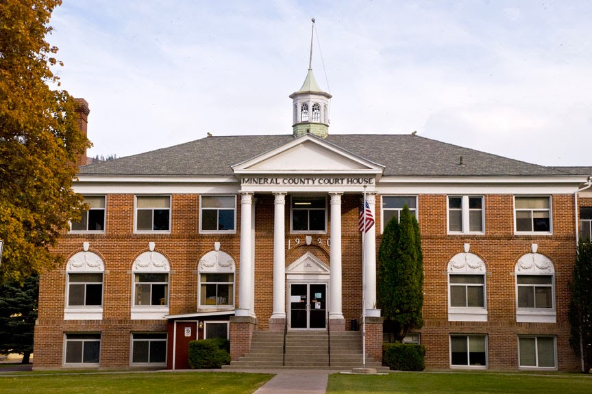
The Mineral County Court House
Superior, Montana
October 17th, 2009

The lure of gold brought miners to the mountainsides of the area in the 1860s, and in 1869, one settler called his home Superior City, after his hometown in Wisconsin.  The Post Office was established in 1871, and the rest is history.  Today the town straddles the Clark Fork River, with the old Mullan Road to the north and Interstate 90 and the Burlington Northern Railroad to the south, both running parallel to the river.  The town hosts the county fair and rodeo every August and is home to the only hospital in the county, the Mineral Community Hospital.  The old school house is a fixture on River Street, the main commercial street in town, and while it no longer serves as a school, it does provide a type of community center for the town and is home, every June, to the Old Schoolhouse Rocks Car Show, one of western Montana's larger car shows.

Alberton is the only town east of Superior, and sits right at the Missoula County (# 4) line.  Ten of the county's sixteen locations on the National Register of Historic Places are in or near Alberton, including the Alberton School built in 1919 and still in service, the Alberton United Methodist Church, the Milwaukee Railroad Depot, and several homes.  The Natural Pier Bridge across the Clark Fork River is also on the National Register.  Wikipedia says this about the bridge:  "Built in 1917 by the Lord Construction Company of Missoula, Montana, it is one of only a few remaining bridges of its type [a steel Warren through truss bridge] in the state, and of those it is the only one that incorporates a natural feature in its design."   Of course what I find most interesting about Alberton is the Montana Valley Book Store, an emporium claiming over 100,000 used books, and a place I never tire of visiting.  It's "open 9-7 everyday all year."


The Natural Pier Bridge
Alberton, Montana
January 3rd, 2010

A bit west of the mid point on I-90's traverse of the county, the Clark Fork River makes an abrupt turn to the northeast, and flows into Sanders County (# 35) where it turns west again to flow out of Montana and into Lake Pend Oreille in Idaho's northern panhandle.  At the first bend, the St. Regis River, which has been draining Mineral County's West End flows into the Clark Fork.  The town that grew up at this confluence is St. Regis, named by Father DeSmet for the Jesuit Saint, Regis de Borgia (one of those Borgias).  Well, actually, there was never a St. Regis de Borgia, at least according to the web site devoted stamps and postmarks honoring St. Francis Borgia, the third General Superior of the Jesuits.  Father DeSmet apparently conflated St. John Francis Regis, S.J., and St. Francis (de) Borgia, S.J., one of the great grandchildren of Pope Alexander VI, and grand nephew of Lucretia Borgia.  The things you learn.  Apparently, while the Pope may be infallible, at least speaking ex cathedra, Father DeSmet wasn't.  As the first Montana town of any size that you encounter driving east on I-90, St. Regis has developed quite a shopping center for restaurants, tourist souvenirs, and antiques.


Abandoned Mine Sheds
Sloway Region (between Superior and St. Regis), Montana
March 19th, 2015

From Henderson west you are in what Mineral County calls the West End.  Henderson had a post office from 1904 until 1930, when mail was sent to De Borgia, the next "town" west.  I believe De Borgia still has a post office.  Its zip code is 59830.  But the De Borgia school, another building on the National Register, has been closed as a school since 1958.  Today it serves as a community center for the West End.  A couple of miles west of De Borgia is Haugan, another place named for a Milwaukee Road officer.  Calling it a town would be pushing things, but it is home to Lincoln's 50,000 Silver Dollar Bar, a place well worth a visit if you need tourist kitch, a bowl of soup, or a look at more silver dollars than you have probably ever seen in one place.  Oh hell, if you've ever seen 50,000 silver dollars anywhere else, I'd be surprised.  Next door to the bar is the Savenac Historic Nursery, at one time one of the USDA's largest tree nurseries, supplying over 12 million seedlings annually for the Forest Service.


Savenac Historic Nursery
Haugan, Montana
April 7th, 2015

Traveling another six miles west will bring you to Saltese, population sixteen.  Named for a Nez PercĂ© chief who lived in the area, Saltese was a mining town and rest stop for people on the Mullan Road.  From here on, it's all uphill traveling west.  Cheney says that the town kept its jail open for weary hobos.  Unfortunately, the Old Montana Bar and Grill, the largest building in Saltese, is currently closed.  And five miles west of Saltese, you'll see Exit 5, Taft Area.  Don Spritzer, in his Roadside History of Montana, refers to Taft as the Wickedest City in America.  Built by the Milwaukee Road when they were blasting tunnels through the mountains, Taft sported a good number of saloons and bawdy houses, none of which survived the 1910 fires that devastated western Montana and northern Idaho.  The Taft Hotel stayed open for tourists on U.S. Highway 10, but was torn down when Interstate 90 replaced the original highway through this area.  Finally Exit 0 will take you to the Lookout Pass Ski Area on the Montana/Idaho border.  In the summer, you can buy your tickets to the Hiawatha Trail at the ski resort.  In short, there's a lot to see and do in Mineral County.


Sunday, January 25, 2015

44. Wheatland County


Would it surprise you to learn that the principal industry in Wheatland County is agriculture, and that wheat itself is an important crop, with over 37,000 acres of land devoted to raising that particular grain?  Located just south of the geographic center of Montana, Wheatland County was created on February 22, 1917 with land taken from Meagher County (# 47) which lies to the west and Sweet Grass County (# 40) which lies to the south.  Almost square in shape, the county covers 1,428 square miles and as of the 2013 Census estimate, 2,134 people called it home.  In 1920, by comparison, the U.S. Census counted 5,619 people living within the county, a number that has never been equaled since.  In fact, each successive enumeration has shown fewer people living in the county than the preceding count, with the single exception of the 2000 Census which showed an increase of 0.6% over the 1990 Census.

The Wheatland County Court House
Harlowton, Montana
September 8th, 2007

At the crossroads of US Highway 12 and US Highway 191, Harlowton is the only city in the county, and serves as the County Seat.  From its origin in 1900 as a stop on the Montana Railroad, up until 1974 when the Chicago, Milwaukee, St. Paul and Pacific (The Milwaukee Road) ceased operations, Harlo (as it's affectionately known) was a rail town.  It was even named for the President and founder of the Montana Railroad, Richard A. Harlow.  Harlow's original idea was to connect the Northern Pacific line at Lombard (Broadwater County, # 43) to the mining camps in the Castle Mountains of Meagher County (# 47), but by the time the track was laid, the mines were all but played out.  Harlow decided to continue the line to Lewistown in Fergus County (#8) and followed the Musselshell River to a point where the track turned north.  At that "turning point" the town he named for himself was born.

In 1908, the Montana Railroad became part of the western expansion of the Milwaukee Road.  Eventually, the Milwaukee reached Seattle, Bellingham, Washington, and even the Olympic Peninsula in western Washington State.  By 1914 the difficulties of running steam engines through the mountains of western Montana led to the decision to electrify the line--at least from Harlowton on to Avery, Idaho.  Harlo was the switching point where the new electric locomotives were put on the west bound trains and taken off those east bound.  It's much too much of a simplification to say that the Arab Oil Embargo of the early 1970s did in the Milwaukee.  The railroad had plenty of problems of its own causing.  But the sad fact is that the company made the decision to end electrified rail service in 1974, and then had to deal with the increased cost of diesel fuel, not to mention the cost of replacing all their electric stock.  By 1980, all Milwaukee operations west of Miles City, Montana ceased.  Today it is remembered in Montana by its beautiful stations, and by displays in Harlowton and Deer Lodge of the last of the electric locomotives.

Welcome to Harlowton
Electric Locomotive on display at the Welcome Park
September 8th, 2007

Harlo's business district was destroyed by a fire in 1907.  Twenty-four buildings, including the only hotel in town, were lost.  Local businessman A.C. Graves built a new hotel, but located it on the bluff above the railway station, and built it from locally quarried sandstone.  The Graves Hotel opened in 1909 with forty-five rooms, a restaurant and lobby, and a veranda on the second floor.  The loss of the Milwaukee cost Harlowton dearly, and the Graves Hotel felt that loss as well.  The largest privately owned building in the community, it stood sentinel on its hilltop,   There are reports that the hotel is haunted, but new owners are determined to restore the place, including its restaurant and coffee shop, and they look to reopen the hotel as a bed and breakfast.  They have put together a very colorful (in every sense of the word) website which includes a page of beautiful photographs of the Wheatland County landscape.


The Graves Hotel
Harlowton, Montana
July 30th, 2011

The Harlowton Women's Club has put together a county history which is included in the online Montana Memory Project.  Yesteryears and Pioneers contains over four hundred pages of Wheatland County memories, including stories of ten different communities, most of which today are mere memories themselves.  Apparently the oldest community in the county is Shawmut, located on U.S. Highway 12 in the southeastern corner of the county.  The post office in Shawmut dates from 1885 according to US Post Office records, and was run by a Mr. Francis Shaw, originally from Boston, Massachusetts.  The Shawmut Peninsula is where Boston's first streets were laid, and the name figures prominently in Boston history.  Shawmut, Montana, on the other hand, isn't even an incorporated town, and in 2010, the Census counted 42 people as residents.  Yesteryears and Pioneers, however, gives quite a history for this community which at one point boasted a hotel, a school, a bank, several shops, saloons (of course, this is Montana), a barber shop, restaurant, etc.  Today, Shawmut is probably best known as the community nearest to Deadman's Basin, a 1900 acre reservoir that draws fishermen from all over central Montana.

At the northern end of the county, along U.S. Highway 191, lies the town of Judith Gap.  Located at the low point between the Big Snowy Mountains and the Little Belt Mountains, the area has been traveled for centuries as the pass permitted movement between the southern part of the state and the central section.  With 126 residents as of the 2010 Census, Judith Gap is more than just a wide spot on the road.  The community itself grew with the coming of the railroad.  Seven saloons, a hotel, a bank, and all the various shops supported a community of 1,000 people.  The Great Northern Railway built a roundhouse and repair shop in the town, employing 250 folk in the early part of the twentieth century.  Grain elevators became the dominant buildings on the skyline as the area shipped wheat to market.  Surprisingly, the town had Montana's first cheese factory--not that it lasted very long, and also a cigar factory.

The Musselshell River
Two Dot, Montana
July 30th, 2011

Perhaps the most iconic of Montana's towns is located on the western end of the county, near the Meagher County line.  Two Dot got its name from the cattle brand used by the rancher who donated the land for the town.  The first post master was commissioned in 1900, and the town grew up around the railyard.  But make no mistake, Two Dot was and is a cattle town.  And just in case you're working on it, number 96 on the Great Falls Tribune's "A Montana Bucket List" is "Stop for a burger at the Two Dot Bar."

Friday, June 8, 2012

28. Powell County

Deer Lodge County (30) was one of the original counties created by the Montana Territory in 1864.  The county seat was at Deer Lodge, a town that had also been known as Spanish Fork, Cottonwood, LaBarge City and Idaho City.  In 1901, the Montana Legislature split off the northern section of the county to form Powell County, with Deer Lodge (the city) as seat.  Powell County covers 2,333 square miles, stretching over 100 miles from north to south.  The 2010 U.S. Census counted 7,027 residents, down 2.1% from the 2000 count which, at 7,180 was the highest ever recorded in the county.  The county takes its name from Mount Powell which was named for one of the first settlers in the county, John W. Powell. Granville Stuart said Powell was in this region as early as 1856 and located a ranch at the foot of the mountain in 1864.
Powell County's history is full of Montana firsts.  Meriwether Lewis, on his return from the coast, traveled across what is now Powell County in 1806. The first gold strike in Montana occurred at Gold Creek in 1852.  The Mullan Road, connecting Fort Benton to Fort Walla Walla crossed the county in 1860, using much the same route as Lewis's 1806 adventure.  Montana Territory authorized the building of a prison in Deer Lodge in 1870.   In 1878 the Presbyterian Church built Montana College in Deer Lodge, the first institution of higher education in the territory.  The Northern Pacific Railroad drove their "golden spike" near Gold Creek in 1883.  The NP was the first transcontinental railroad built in the northern half of the country. 


The Powell County Court House, Deer Lodge, Montana
Deer Lodge is the only incorporated city in the county.  The town was incorporated in 1864 and was named seat of the newly created Deer Lodge County in 1867.  When in the 1890s, nearby Anaconda lost the battle to become state capitol, it took on as a consolation prize the role of county seat.  Upon the creation of Powell County in 1901, the new county's seat returned to Deer Lodge.  Today Deer Lodge is a city of 3,111 residents according to the 2010 U.S. Census.  In addition to its role as County Seat, Deer Lodge remains home to the Montana State Prison, now housed in a modern facility on the flanks of Mount Powell west of town.  The original Territorial Prison still stands in the middle of town, now housing several different historic displays including the Old Montana Prison, the Montana Auto Museum, Yesterdays Playthings, Frontier Montana and the Powell County Museum, all run under the auspices of the Powell County Museum.  Included as part of the Museum's collection are a number of Milwaukee Railroad items, including Little Joe, an electric locomotive so named because it was originally intended for use on Joseph Stalin's railroads in the Soviet Union.  
Little Joe, Old Prison Museum Complex, Deer Lodge, Montana

Just north of town lies the Grant Kohrs Ranch, a National Historic Site administered by the National Park Service.  The park today covers 1,600 acres, but in its heyday, the ranch was headquarters for a ten million acre spread.  Visitors to the park can see some eighty historic structures, including the historic ranch house, the bunkhouse, the blacksmith shop, horse barns, and cattle sheds.  To this day the Grant Kohrs Ranch is a working cattle ranch, the only National Historic Site still functioning as such.  Novelist Patricia Nell Warren grew up on the ranch and set her novel The Fancy Dancer in Deer Lodge (renamed Cottonwood in the novel).

The far northern end of the county is a mountainous region and home to much of the Bob Marshall Wilderness Area, the fifth largest wilderness area in the contiguous forty-eight states.  South of the mountains, the Ovando Valley along the Blackfoot River is home to many cattle ranches and is a sportsman's paradise with first class hunting and fishing available.  Brown's Lake, east of Ovando, finds its water disputed between the fishermen and the windsurfers who come to take advantage of the constant afternoon winds that blow across the water.  The lake has arguably the best windsurfing in western Montana.  Driving south on Montana 141, you'll pass near Helmville, home of what may be the best small town rodeo in the country.  Held every Labor Day weekend, the rodeo attracts visitors from all over.  The official Montana State Travel website refers to it as "the biggest little rodeo in Montana."
Powell County Farm.  Little Blackfoot River Canyon near Avon, Montana
Continuing south on Montana 141, you'll pass the Nevada Creek Reservoir and arrive in Avon, another small Powell County town, and home to the Avon Family Cafe.   I find it somewhat amusing that the Yahoo Travel site for the cafe lists it as a pizza restaurant.  I've had many a great breakfast there, and will often stop for lunch, but never once have I had a pizza there.  I don't recall even seeing pizza on the menu.  The homemade pies, however, are well worth a stop if you're driving by on your way between Helena and Missoula.  U.S. Highway 12 passes right in front of the restaurant, following the routes of Meriwether Lewis in 1806 and the Mullan Road of 1860, both mentioned above.  This is the canyon of the Little Blackfoot River, a scenic valley with high rock formations lining the sides of the canyon and lush farmlands along the canyon floor.
 Thirteen miles west of Avon, U.S. Highway 12 meets Interstate 90 at Garrison.  Garrison is also where the Butte, Anaconda and Pacific Railway's northern terminus joins the Burlington Northern Railroad's tracks operated under lease by Montana Rail Link.  The railroad has always played an important role in Powell County, from 1882 on.  In that year, the Utah Northern built a line from Butte to the mouth of the Little Blackfoot (now known as Garrison).  As noted above, the Northern Pacific completed the first northern transcontinental railroad by driving the "golden spike" at Gold Creek in 1883.  The Milwaukee Road (Chicago, Milwaukee, St. Paul and Pacific) came through in the first decade of the 1900s, and Deer Lodge was a division headquarters for that line.  Unfortunately, the Milwaukee closed all Montana operations in 1980, and nothing has taken its place as far as employment in Powell County is concerned.  Agriculture accounts for 23% of the county's industrial base, at least as far as male employment is concerned, with Public Administration following at 16%.  Public Administration accounts for 19% of female employment, for in addition to the Powell County offices and the state prison, Montana's Department of Justice Vehicle Licensing Bureau has its headquarters in Deer Lodge.  
The Montana Territorial Prison, Deer Lodge, Montana
Powell County's website can be found at:  http://www.powellcountymt.gov/
The Powell County Chamber of Commerce has an informative site at:  http://www.powellcountymontana.com/
Photo Information:  (All photographs were taken with a Nikon D80 DSLR and a Nikkor 16-85 mm wide angle/tele/zoom lens unless otherwise noted.   Clicking on any photograph will open a full-sized image in a new window.)

Powell County Sign:  Taken 3/24/2010 on Interstate 90 at the Granite/Powell County Line.  Focal length 85 mm.  ISO 125, f /11.0, 1/250 second.

Powell County Court House:  Taken 10/3/2009 in Deer Lodge, Montana.  Focal length 16 mm.  ISO 125, f /16.0, 1/45 second.

Little Joe Locomotive:  Taken 4/1/2010 in Deer Lodge, Montana.  Focal length 22 mm.  ISO 100, f /27.0, 1/8 second.

Powell County Farm (Little Blackfoot Valley):  Taken 7/1/2011 along US Highway 12, Powell County, Montana.  Focal length 70 mm. ISO 125, f /8.0, 1/60 second.

The Montana Territorial Prison:  Taken 4/1/2010 in Deer Lodge, Montana.  Focal length 62 mm.  ISO 100, f /38.0, 1/6 second.