Showing posts with label Montana. Show all posts

Saturday, August 8, 2015

55. Petroleum County


Looking at things objectively, there is little reason today for Petroleum County to exist.  Created on February 25, 1925 when the Montana State Legislature approved chopping off the eastern end of Fergus County (# 8), Petroleum County today has roughly 500 residents spread over 1,674 square miles of rolling plains.  It is the smallest county by population in the state of Montana, and the seventh smallest nationally.  When I stopped at the Court House in Winnett, the County Seat, I asked if there was any movement for the county to be reabsorbed into Fergus.  I was told "Absolutely not."  How five hundred people pay for a county government I have no idea. The woman I spoke with in the Court House told me that there are only four full-time employees, but even so.  Now I have to say, I don't know which four she was counting as county employees, but the county's web page lists ten people in addition to the three county commissioners.  Of course, many of those ten could be part-time employees.

Petroleum County is so named for the oil fields that were discovered in the Cat Creek area in 1920. Bounded on the north by the Missouri River and on the east by the Musselshell River, the southern and western boundaries are those straight lines we associate with man made distinctions, the southern line being the continuation of the division between Fergus (# 8) and Musselshell (# 23) counties that preceded the creation of Petroleum County.

The Petroleum County Community Library states that it is "Dedicated to the preservation of local history," and to that end the folks who serve as library staff and volunteers have collected and saved the local newspaper (The Winnett Times) back to 1921, and in 1979 began a project of collecting oral histories from the eldest residents of the county.  In 1985 the project changed to one where questionnaires were used to collect information from county residents, which information was then condensed into a book Pages of Time--History of Petroleum County, from which I have gratefully taken much of the information in this post.

The Petroleum County Court House
Winnett, Montana
Taken March 26th, 2010

Located slightly south and west of the county's center, Winnett is both the largest community and the seat of the county.  Walter John Winnett (WJ), a Canadian rancher, was captured by the Sioux and eventually adopted into the tribe.  He started ranching in Montana Territory in 1879, and built his ranch home in 1900.  In 1910, he built a store and petitioned the US government for a post office.  That marks the "official" birth of the town of Winnett, although it wasn't until 1913 that the Milwaukee Land Company, an adjunct of the Chicago, Milwaukee, St. Paul and Pacific Railroad (The Milwaukee Road), secured land from rancher Winnett and platted a township which the company named for the rancher.  The town grew rapidly, with many businesses located in the downtown area, and in 1917, WJ began construction of a two story sandstone building that became known as the Winnett Block.  Originally housing a bank, a restaurant, the newspaper's printing shop, a lumber/hardware store with business offices on the second floor, by 1929 the building had become the county's Court House, as seen above.  Today, Winnett counts 182 residents (2010 U.S. Census), down from an all time high of 408 in 1950.  The three schools that make up the Public School system for the county have a total of 12 teachers (including one librarian) and 103 students in grades K-12.  All three schools (elementary, junior high and high school) are on the same block in town.  City-Data.com is usually good about listing all the churches in a county, but the site for Petroleum County says only that there is one Roman Catholic Church with 158 members in 2010 and the balance of county residents, 336 in number, being unchurched.  I wonder how the members of the United Methodist Church, First Baptist Church and First Lutheran Church, all of which appear in the city-data.com page for Winnett feel about that.

The Rural Petroleum County Landscape
Taken March 26th, 2010

Pages of Time divides its story into eleven chapters, based on historic post offices and the communities that they served.  It shows 19 post offices that existed once upon a time, but of those, only three communities remain today.  Cat Creek, where were located the oil fields that give the county its name, lies in the eastern part of the county, near the Musselshell River north of Highway 200.  The wells were abandoned in 1975, although new exploration has focused on natural gas and several new wells have been drilled, introducing fracking to the area. The Cat Creek area has also been known as Frantz, Frantzville, and Shay.  Curiously, for a place with such an important part in the county's history, it does not appear on my 1994 Montana Atlas and Gazetteer.

Flatwillow is an unincorporated community in southern Petroleum County, not far from the Musselshell County line.  While it does appear on the maps, its post office, which opened in 1883, six years prior to Montana's statehood, has been closed since 1946.  Teigen, on Highway 200 near the Fergus County line, is another unincorporated community whose Post Office closed in 1983.  If you're so inclined, however, you can use a Zip Code, 59084, to address any mail you have for Teigen.  I suppose such mail will be delivered out of Winnett, Zip Code 59087.  Other communities that might have been include Petrolia, Hoyleville, Ashley, Blakeslee, and Dovetail, all little more than dreams of the people who homesteaded the area in the early days of statehood.

An Abandoned Home or Business?
Winnett, Montana
Taken March 26th, 2010

Recreational opportunities include War Horse National Wildlife Refuge in the northwestern part of the county.  Part of the Charles M. Russell Complex, War Horse is comprised of three separate units that cover some 3,200 acres. Each of the three units has its own lake, with Wild Horse and War Horse Lakes being two of the largest bodies of water in the county.  Petrolia Lake, a dammed reservoir southeast of Winnett, is featured in several fishing oriented websites.  The site Hook and Bullet says this:  Whether you're fly-fishing, spinning, or baitcasting your chances of getting a bite here are good.  On the other hand, Iceshanty.com has a lot of reports, all from 2007, about poor fishing conditions, presumably from ice fishing for perch.  The northern extent of the county lies within the Charles M. Russell National Wildlife Refuge along the Missouri and Musselshell Rivers.  The Crooked Creek Campground, 52 miles northeast of Winnett, has a boat ramp, which may or may not be usable due to fluctuating water levels in the Fort Peck Reservoir.  It also has twenty campsites each with picnic table and fire pit, potable water, and a swimming area.  CentralMontana.com says that the drive is a "beautiful scenic drive," and I'll take their word for it, as I personally have not been on that road.  I'm saving that for my next trip to Petroleum County.

Tableland Southeast of Winnett
Winnett, Montana
Taken March 26th, 2010

In closing, I post below the poem, written by Marjorie W. King, that the Petroleum County Community Library has on its home page.  While the words could apply to just about anywhere in Montana, they speak volumes to me about the love of a people for their home.
Petroleum County is March, roaring in like a lion, lambing sheds full of bleating sheep, two-year-old heifers waiting impatiently unsure of the stirrings within them, and old cows seeking shelter in the willows.  It is soft spring winds with the smell of damp sage. V's of honking geese and meadowlarks who sing as though they alone had discovered spring.  It is the taste of fresh rhubarb and new-grown asparagus.  It is seeding and branding and watching the sky for June rains.  It is hope.
 Petroleum County is cloudless broad skies and new-mown hay, and black rolling thunderclouds shaking fingers of lightning at those who dare to venture forth.  It is August and dry hot winds that wither the grass with dust devils teasing and skipping away.  It is fear--fear of prairie fires and drought and grasshoppers and debt.  It is utter discouragement. 
Petroleum County is bountiful harvests and fat lambs and calves.  It is chokecherry syrup and bright orange pumpkins and huge harvest moons.  It is the first snowfall quietly covering the harshness of the landscape.  It is long evenings and howling coyotes and northern lights.  It is nights filled with millions of stars, and galaxies for those who search for them.  It is acceptance of life.
Petroleum County is wind and blizzards, and worry for man and beast alike.  It is the unmistakable blue of chinook clouds.  It is everything that is beautiful.


Sunday, April 12, 2015

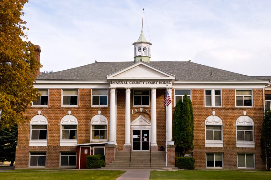
54. Mineral County


As might be expected in a county named Mineral, mining has a rich history in this small county on the Montana/Idaho state line.  On August 7, 1914, a portion of Missoula County (# 4) straddling the Clark Fork and St. Regis river canyons in the Bitterroot Mountains became the new Mineral County, with Superior, the largest town being named County Seat. The Milwaukee Road played an important part in the history of the county, both for the good and the bad.  When the railroad first came through these canyons, Alberton at the eastern end of the county became a division point on the line, and the town was even named for the President of the railroad, Albert J. Earling. (Note that Roberta Carkeek Cheney, in her Names on the Face of Montana, claims the town was named for a family of early settlers, the Alberts.)  Further west, a guest at the Superior Hotel in Superior asked permission and placed the first ever Gideon Bibles in the rooms of the hotel.  I have read that he was passing through town on a passenger train, but I can't confirm that.  Haugan, in the county's West End, was a railroad town, as was Taft, "The wickedest city in America."  Today, Haugan is little more than the 50,000 Silver Dollar Bar, and Taft is just an exit from Interstate 90.  The Milwaukee Road ceased operations in the west in 1979, and most of the railbed ended up in the hands of private individuals.  In western Mineral County, the roadbed is used as a hiking/biking trail, and the wonderful series of tunnels and trestles from the Montana line west into Idaho has been turned into the Route of the Hiawatha Trail, a bike ride I highly recommend.

To the best of my knowledge, Lewis and Clark never made it to what is now Mineral County, but Lieutenant John Mullan did.  Given the task of connecting the head of river transportation on the Missouri at Fort Benton to the administrative capital of Washington Territory at Fort Walla Walla, John Mullan reached this area in the 1850s.  In 1859, he returned with a crew of military and civilian laborers to build the 640 mile road that to this day bears his name.  The Mineral County Museum in Superior has a significant display honoring Mullan and his work, and as History Link, the People's History Library says, "It is a tribute to his skill and vision that freeway I-90 follows his route almost to the foot through its most rugged stretches."

The Mineral County Court House
Superior, Montana
October 17th, 2009

The lure of gold brought miners to the mountainsides of the area in the 1860s, and in 1869, one settler called his home Superior City, after his hometown in Wisconsin.  The Post Office was established in 1871, and the rest is history.  Today the town straddles the Clark Fork River, with the old Mullan Road to the north and Interstate 90 and the Burlington Northern Railroad to the south, both running parallel to the river.  The town hosts the county fair and rodeo every August and is home to the only hospital in the county, the Mineral Community Hospital.  The old school house is a fixture on River Street, the main commercial street in town, and while it no longer serves as a school, it does provide a type of community center for the town and is home, every June, to the Old Schoolhouse Rocks Car Show, one of western Montana's larger car shows.

Alberton is the only town east of Superior, and sits right at the Missoula County (# 4) line.  Ten of the county's sixteen locations on the National Register of Historic Places are in or near Alberton, including the Alberton School built in 1919 and still in service, the Alberton United Methodist Church, the Milwaukee Railroad Depot, and several homes.  The Natural Pier Bridge across the Clark Fork River is also on the National Register.  Wikipedia says this about the bridge:  "Built in 1917 by the Lord Construction Company of Missoula, Montana, it is one of only a few remaining bridges of its type [a steel Warren through truss bridge] in the state, and of those it is the only one that incorporates a natural feature in its design."   Of course what I find most interesting about Alberton is the Montana Valley Book Store, an emporium claiming over 100,000 used books, and a place I never tire of visiting.  It's "open 9-7 everyday all year."


The Natural Pier Bridge
Alberton, Montana
January 3rd, 2010

A bit west of the mid point on I-90's traverse of the county, the Clark Fork River makes an abrupt turn to the northeast, and flows into Sanders County (# 35) where it turns west again to flow out of Montana and into Lake Pend Oreille in Idaho's northern panhandle.  At the first bend, the St. Regis River, which has been draining Mineral County's West End flows into the Clark Fork.  The town that grew up at this confluence is St. Regis, named by Father DeSmet for the Jesuit Saint, Regis de Borgia (one of those Borgias).  Well, actually, there was never a St. Regis de Borgia, at least according to the web site devoted stamps and postmarks honoring St. Francis Borgia, the third General Superior of the Jesuits.  Father DeSmet apparently conflated St. John Francis Regis, S.J., and St. Francis (de) Borgia, S.J., one of the great grandchildren of Pope Alexander VI, and grand nephew of Lucretia Borgia.  The things you learn.  Apparently, while the Pope may be infallible, at least speaking ex cathedra, Father DeSmet wasn't.  As the first Montana town of any size that you encounter driving east on I-90, St. Regis has developed quite a shopping center for restaurants, tourist souvenirs, and antiques.


Abandoned Mine Sheds
Sloway Region (between Superior and St. Regis), Montana
March 19th, 2015

From Henderson west you are in what Mineral County calls the West End.  Henderson had a post office from 1904 until 1930, when mail was sent to De Borgia, the next "town" west.  I believe De Borgia still has a post office.  Its zip code is 59830.  But the De Borgia school, another building on the National Register, has been closed as a school since 1958.  Today it serves as a community center for the West End.  A couple of miles west of De Borgia is Haugan, another place named for a Milwaukee Road officer.  Calling it a town would be pushing things, but it is home to Lincoln's 50,000 Silver Dollar Bar, a place well worth a visit if you need tourist kitch, a bowl of soup, or a look at more silver dollars than you have probably ever seen in one place.  Oh hell, if you've ever seen 50,000 silver dollars anywhere else, I'd be surprised.  Next door to the bar is the Savenac Historic Nursery, at one time one of the USDA's largest tree nurseries, supplying over 12 million seedlings annually for the Forest Service.


Savenac Historic Nursery
Haugan, Montana
April 7th, 2015

Traveling another six miles west will bring you to Saltese, population sixteen.  Named for a Nez PercĂ© chief who lived in the area, Saltese was a mining town and rest stop for people on the Mullan Road.  From here on, it's all uphill traveling west.  Cheney says that the town kept its jail open for weary hobos.  Unfortunately, the Old Montana Bar and Grill, the largest building in Saltese, is currently closed.  And five miles west of Saltese, you'll see Exit 5, Taft Area.  Don Spritzer, in his Roadside History of Montana, refers to Taft as the Wickedest City in America.  Built by the Milwaukee Road when they were blasting tunnels through the mountains, Taft sported a good number of saloons and bawdy houses, none of which survived the 1910 fires that devastated western Montana and northern Idaho.  The Taft Hotel stayed open for tourists on U.S. Highway 10, but was torn down when Interstate 90 replaced the original highway through this area.  Finally Exit 0 will take you to the Lookout Pass Ski Area on the Montana/Idaho border.  In the summer, you can buy your tickets to the Hiawatha Trail at the ski resort.  In short, there's a lot to see and do in Mineral County.


Monday, March 23, 2015

52. Wibaux County

There are two county names in Montana that out-of-staters (and some Montanans) routinely mispronounce.  The other one is Meagher County (# 47).  There are two counties in Montana where the county seat bears the same name as the county itself.  The other is Missoula (# 4).  Roberta Carkeek Chaney, in her book Names on the Face of Montana, felt obliged to indicate the pronunciation of Wibaux both for the county and for the town.  As she says, "Wibaux (pronounced Wee-bo)" with long marks over both ees and the o.  If Meagher County was named for some renegade Irishman who ended up becoming a territorial governor of Montana, Wibaux, both town and county, were named for a French immigrant who became one of the wealthiest cattle barons in Montana history, Pierre Wibaux.  Chaney says that Wibaux was a French Huguenot (which she spells without the second "u," but it's hard for me to accept that when one of the National Historic Places in Wibaux County is the Roman Catholic Church, St. Peter's, which history tells us was built at the request of Wibaux's father.  I just can't picture a Huguenot building a Catholic church.

Situated on the North Dakota state line, Wibaux County is one of the smallest in area in eastern Montana.  Driving across the county on Interstate 94, it's less than twenty miles from the North Dakota line to the point where you enter Dawson County (# 16) on the west.  North to south, from the Richland County (# 27) line to the Fallon County (#39) line, you'll cross roughly 53 miles of Wibaux County, giving the county a total land area of 890 square miles.  The 2010 US Census counted 1,017 people in the county, the lowest number ever counted there, and one third of what the 1920 Census showed.  The 2013 estimate, however, showed a 10% increase, bringing the count up to 1.121.  Even by Montana standards, this is a low population for a county.  The county was created on August 17, 1914, with land taken from Dawson County, although some references say that land came from Fallon and Richland Counties as well.  While numerous small towns have, at some point, existed in Wibaux County, today the seat is the county's only incorporated town, and indeed, every address in the county bears the same zip code, 59353, since the whole county is served out of the Post Office in the seat.

The Wibaux County Courthouse
Built 1953
Photo taken October 7th, 2009
Wibaux, Montana

The town of Wibaux was originally named Keith, or possibly Beaver, then Mingusville.  It sits on Beaver Creek which runs the length of the county, north to south, and whose water attracted early day settlers to the area.  Chaney says that Keith had its post office established in 1882, but that the name was changed to Mingusville in 1884, and finally to Wibaux in 1895.  I'm not sure who Keith was, but Mingusville got its name from Minnie and Gus Grisy, early day settlers.  The story, perhaps apocryphal, is that Wibaux's ranch hands surrounded the town, essentially laying siege to it, until the town agreed to take the rancher's name--the one it still holds.  Another story, which definitely sounds apocryphal but clearly isn't, concerns our 26th President, Theodore Roosevelt, who out for a ride, found himself in a bar in Mingusville.  The National Park Service's website for Theodore Roosevelt National Park in North Dakota quotes the man himself:

“It was late in the evening when I reached the place. I heard one or two shots in the bar-room as I came up, and I disliked going in. But there was nowhere else to go, and it was a cold night. Inside the room were several men, who, including the bartender, were wearing the kind of smile worn by men who are making believe to like what they don’t like. A shabby individual in a broad hat with a cocked gun in each hand was walking up and down the floor talking with strident profanity. He had evidently been shooting at the clock, which had two or three holes in its face. 
…As soon as he saw me he hailed me as ‘Four Eyes,’ in reference to my spectacles, and said, ‘Four Eyes is going to treat.’ I joined in the laugh and got behind the stove and sat down, thinking to escape notice. He followed me, however, and though I tried to pass it off as a jest this merely made him more offensive, and he stood leaning over me, a gun in each hand, using very foul language… In response to his reiterated command that I should set up the drinks, I said, ‘Well, if I’ve got to, I’ve got to,’ and rose, looking past him. 
As I rose, I struck quick and hard with my right just to one side of the point of his jaw, hitting with my left as I straightened out, and then again with my right. He fired the guns, but I do not know whether this was merely a convulsive action of his hands, or whether he was trying to shoot at me. When he went down he struck the corner of the bar with his head… if he had moved I was about to drop on my knees; but he was senseless. I took away his guns, and the other people in the room, who were now loud in their denunciation of him, hustled him out and put him in the shed.”
Downtown Wibaux, Montana
Taken October 7th, 2009

My own history with Wibaux goes back to my childhood, when my Methodist Minister father was serving as Vice-President at Rocky Mountain College.  He was often called to fill in for churches needing temporary pastors, and one of the churches he served in this way was the Methodist church in Wibaux.  I don't remember much about the church itself (I was seven at the time), but I do remember those long drives across eastern Montana every week.  Today, with Interstate 94 to follow, it's 250 miles from Billings to Wibaux.  In those days, we followed U.S. Highway 10 along the Yellowstone River at a much slower pace than today.

The Wibaux United Methodist Church
Taken October 7th, 2009
Wibaux, Montana

Roughly half the population of the county lives in the town of Wibaux.  The rest of the county's people are ranchers and farmers, with 40% of the men and 9% of the women engaged in agriculture, according to City-Data.com.  The average size farm is 2,492 acres and livestock or poultry accounts for over 61% of the total agricultural market value in the county.  But should you be traveling through this part of the state, by all means get off I-94 at exit 241 if only to visit the Beaver Creek Brewery.  The only microbrewery on a 600 mile stretch between Billings and Fargo (according to the Craft Beer website), Beaver Creek Brewery can provide you with not only great home-crafted beer, but also their own root beer, and bread made from the brewing process's spent grain.  As they say on their website, if you're going to succeed in a town as small as Wibaux, you have to offer something for everyone.


Wibaux County Landscape
Off MT Highway 7
Taken August 26th, 2011


Sunday, March 15, 2015

51. Jefferson County


Twenty-six counties in the United States are named, directly or indirectly, for President Thomas Jefferson.  Only George Washington has more counties named for him (31).  Of the twenty-six, three are only indirectly named for the third President.  Montana's is one of those three, being named for the Jefferson River, one of the three rivers that come together to form the Missouri at Three Forks.  The Jefferson River, of course, was named for the President, and it flows north from the confluence of the Beaverhead, Ruby and Big Horn Rivers near the town of Twin Bridges (Madison County, #25) till it turns east, forming the boundary between Jefferson County and Madison County.  Eventually, the river joins with the Madison and then with the Gallatin to form the mighty Missouri.  The rivers are named for three men vitally important to the Corps of Discovery, AKA the Lewis and Clark Expedition.  Jefferson was, of course, the President who bought the Louisiana territory from France.  Madison was his Secretary of State and successor as President.  And Albert Gallatin, probably the least famous of the three, was the Secretary of the Treasury who wrote all the checks.  All three have counties named for them in Montana, or rather, there are counties named for the rivers named for the three men.

With the creation of Montana Territory in 1864, governmental functions had to be met, which included county structures.  Montana created nine counties, one of which was never actually organized and which held most of the land in the state.  Big Horn County was pretty much everything east of a line drawn north to south through the center of the state, and it never had a seat or organized county government.  Of the remaining eight counties, Jefferson was next to smallest.  (Only Edgerton County, later Lewis and Clark County, #5, was smaller.)  A stage stop on the way from Fort Benton to Virginia City, Jefferson City, was named seat.  In time, Radersburg (now in neighboring Broadwater County #43) took honors as the seat, but by 1884 the die was cast, and the seat moved to Boulder, another Fort Benton to Virginia City stage stop, and there it remains to this day.  In 1888, county voters approved a $40,000 bond issue to build a courthouse, hiring architect John Paulsen who designed a Richarsonian Romanesque structure of brick and stone with a high gabled roof.  This building remains one of the most visually interesting courthouses in Montana and is on the National Register of Historic Places.

The Jefferson County Courthouse
Boulder, Montana
February 21st, 2010

Boulder, named for the large rocks that lay across the landscape, was originally called Boulder Valley, but lost the second word in 1871.  In 1892, the new State of Montana set aside land and began the process of building the Montana School for the Deaf, Blind and "Backward Feeble Minded Children."  Today the place is called the Montana Developmental Center, and is considered to be the most expensive institution in the state.  The Missoulian reported in 2012 that with 50 residents and 250 employees, the daily cost of housing and treating patients was in excess of $770.   According to the state's official website, "The purpose of the Montana Developmental Center is to provide treatment to people with serious intellectual disabilities who have been determined by a court to pose an imminent risk of serious harm to self or others." Standards did not used to be so strict.  A childhood friend of mine from Laurel, diagnosed with cerebral palsy, spent a good bit of his life at Boulder, no doubt considered one of the backward feeble minded children.

Boulder Hot Springs and Hotel
Boulder, Montana
February 21st, 2010

Another institution on the outskirts of Boulder is the Boulder Hot Springs.  The springs themselves were known to area Native Americans as a spot to relax and, perhaps, heal. In 1863 James Riley, a prospector, built the first structure on the site.  In the 150+ years since, the place has certainly had its ups and downs.  With an outdoor pool, indoor steam rooms and hot plunges segregated by gender, hotel rooms and a restaurant, the place is open today and ready for business.  I recall many wonderful weekends spent at what we then called The Diamond S.

Roughly ten miles east of Boulder is the mining town of Basin.  Gold brought prospectors to the rocky landscape just east of the Continental Divide, and business brought the railroad.  Both the Great Northern and the Northern Pacific served this small town, each with its own station and warehouse.  The two main mines were the Katy and the Hope, both long closed.  A mining engineer, Max Atwater, came up from Butte to run a zinc extraction plant in the small community.  Weavers will recognize that name, for Max's wife was Mary Meigs Atwater, arguably the mother of modern handweaving in the United States.  For eighteen years, from 1993 through 2011, Basin was home to the Montana Artists Refuge which hosted events across the artistic spectrum.  They have a Facebook page, but nothing has been posted since the Refuge closed its doors in October 2011.   Starting in the 1960s and continuing to this day, the mines have attracted a world-wide tourist trade looking for pain relief.  Whether you believe that radon is dangerous or not, you won't keep folk from coming to Basin to visit the Merry Widow Mine.  Visitors claim relief from a wide variety of ailments, and their testimonials bring more visitors every year.  Basin is also home to Montana's first gay rights organization.  When a group of friends and I met to form Out in Montana in the early 1980s, we followed the trail of the Montana Lesbian Coalition which got its start when a lesbian mom living in Basin, ran for school board and caused all hell to break loose.

The Headwaters of the Boulder River
West of Basin, Montana
February 21st, 2010

Jefferson County is one of three counties in Montana to be served by two Interstate highways.  Interstate 15 runs north to south through the county, connecting Basin and Boulder to the larger cities of Butte and Helena.  Interstate 90 runs across the southern edge of the county, past the town of Whitehall, the only incorporated town in the county other than Boulder.  Whitehall got its start as yet another stage stop on the way to Virginia City, and the stage stopped at a large white house on the ranch owned by E.G. Brooke.  Brooke called his home the White Hall, and the name stuck, although in 1877 the Post Office changed it to one word.  Although the town sits at the east end of Homestake Pass, the 6,329 foot pass where I-90 crosses the Continental Divide, Whitehall has long been considered a suburb of Butte, west of the pass.  Veteran NBC newsman Chet Huntley told of how he grew up in Whitehall, graduating from Whitehall High in 1929.  He reported that many of his classmates spent their summers working in the mines in Butte.  Visitors driving by on I-90 will notice two things near the community.  East of town, on the flats before the road rises to cross the mountains, there are a number of homes with large detached buildings beside them.  There are also windsocks visible.  This is the Jeffco Air Park, a planned subdivision aimed directly at those commuters who have their own plane.  I don't think it really caught on as there are, as I recall, at most a half dozen homes with hangars.  Also at Whitehall, visitors will note a large smokestack south of the Interstate near the railroad tracks.  This was the proposed site of a sugar beet factory which never got built. The soil was good for beet growth, but the weather didn't cooperate.  Such is often the case in Montana.

Looking South from Interstate 90
Near Whitehall, Montana
February 14th, 2010

The northern end of Jefferson County is home to several small communities, Clancy, Elkhorn, Jefferson City, and Montana City, all with their histories built upon mining.  What has kept these communities from becoming ghost towns (and to be honest, Elkhorn is a ghost town today, having been abandonned in 1970), is their proximity to the state capital, Helena.  In the 1970s, Jefferson County was the fastest growing county in the state as government employees moved across the county line for lower taxes and more elbow room.  Today Clancy remains one of Helena's most important suburbs with over 1600 residents in the 2010 census.  The county as a whole has almost tripled in population since 1950.  The 2013 estimate counts 11,512 in a county that covers 1,659 square miles.

Sunday, March 8, 2015

50. Garfield County


The state of Montana added seven counties in February and March, 1919.  Along with Treasure (# 33), Garfield County came into being on February 7th of that year.  Prior to that date, what is now Garfield County had been part of Dawson County (# 16) which covered much of eastern Montana at the time.  Bordered by the Missouri River on the north, Garfield County's area of 4,847 square miles coupled with its 2010 US Census count of 1,206 residents, makes it the least densely populated county in Montana, and the third least densely populated county in the U.S. outside of Alaska.  One of the nicknames for the area is The Big Dry (from Big Dry Creek which flows through the county), and the lack of population has led some out-of-state conservationists to suggest that the county would better serve as a wildlife preserve, returning the land to pre-white settlement conditions.  Not surprisingly, most county residents oppose this plan.  Of course, Frank Popper's plan for a Buffalo Commons covers much more than just Garfield County, extending to portions of ten states in the Great Plains region.  Politically speaking, Garfield is probably most famous for being the home of the Montana Freemen, an anti government group whose fraudulent banking practices drew the attention of the FBI.  In 1996, an 81 day standoff between the FBI and the Freemen ended with the group surrendering to government forces.  Of course, there are always at least two sides to any story, and one view is that the Freemen were law abiding citizens unfairly targeted by the FBI.

The Garfield County Courthouse
(Formerly the Garfield County Hospital)
Jordan, Montana
Taken March 26th, 2010

The only incorporated town in the county is Jordan, the county seat.  First settled in 1896 as a cow town, Jordan got its post office in 1899, a post office run by Arthur Jordan.  According to Cheney's Names on the Face of Montana, Jordan suggested the name for the community, but did not name it for himself.  Rather he suggested the name of a friend of his in Miles City, a man also named Jordan.  Writing for the historical collection Garfield County: The Golden Years, Grace Walker says "When we came to Jordan, it was a small town."  Of course, with a 2010 population count of 343, most people would say it is still a small town.  In the same volume, Vivienne Nault Schrank uses the term "tiny."  She remembers asking her mother, "Is this really it, just two houses and three people?"  That was in April, 1913, and other than their own "cherry red HUDSON car," Vivienne saw no other automobiles in town.  The drive from Miles City, some eighty-three miles away had taken them two full days.

Jordan has the only high school in the county, a high school that into the 1990s had a co-ed dormitory for those students who couldn't get home over night.  With a total student body of fifty-six, Garfield County High School serves an area almost as large as the state of Connecticut.  A friend of mine taught English there for several years.  He had great experiences, and apparently was much appreciated.  It's hard to find people these days who want to live out in the middle of nowhere.  As another friend, Bill McRae who grew up on a cattle ranch in Garfield County and has written several guide books for Moon Handbooks puts it in his book Montana, "No one comes to Jordan ... because of its interesting history or architecture."  He goes on to describe Jordan thus:
The most isolated county seat in the continental U.S., Jordan is 175 miles from the nearest major airport, 85 miles from the nearest bus line, and 115 miles from the nearest [passenger] train line.  (McRae, Montana, p. 381)
The first time I visited Jordan back around 1980, I found the water unfit to drink.  Heavily alkaline in nature, a glass of water in a restaurant was just not potable.  Nor was the coffee made with that water.  In 2010, when I stopped in Jordan for lunch, I was studiously avoiding the water glass set before me until the woman seated at the next table spilled hers all over the table and floor, with a good bit splashing on me.  I was amazed that anyone would even attempt to drink the stuff until I figured out what the sign out in front meant.  "New RO."  RO?   Oh, Reverse Osmosis.  The restaurant had put in a water purification system that meant the water, coffee and ice tea actually tasted like something.  Imagine my surprise at finding that you can buy machines to turn your water alkaline.  Fortunately, in Jordan, at least one restaurant is going the other way.


Traffic Congestion in Garfield County
Montana Highway 200
Taken March 26th, 2010

That first trip also included camping overnight at Hell Creek Campground on the shores of Fort Peck Reservoir.  Hell Creek State Park, one of Montana's fifty-four state parks, is twelve miles north of Jordan over a road so bad that even the state parks information site says it will take you a half hour to drive.  Personally, unless they've improved the road considerably in the last twenty years, I think that is an optimistic estimate.  Don't get me wrong, the park is in a beautiful setting, and if you're into playing in the water or fishing for walleye, by all means go visit.  But make sure your tent is securely tied down.  All night long I felt as if we were going to blow into the lake at any minute.

One other thing before we leave Jordan.  When I was there in 2010, I searched for some time looking for the county court house.  Eventually I ended up in front of a rather odd looking building off a back street.  I've seen lots of court houses over the years, and this building did not look like one, yet every bit of information I had said I was in the right place.  I finally went inside and asked.  Yep, this building, originally built as a hospital, was now serving the legal needs of the county.  Apparently, the old court house, a white frame building, had burned down.  Bluehiways3y has a picture of it on Flickr.  You can see it here.

Some Garfield County Residents Getting Their Exercise
Eastern Garfield County
March 26th, 2010

Today, Jordan is the only incorporated town in the county (and it was only incorporated in 1951).  But believe it or not, back in 1919, there was a competition for the honor of being seat of the new county.  Cheney reports that some thirty "settlements" with post offices existed within the boundaries of the new county.  Today there are just four outside of Jordan.  Brusett lies off the main roads, but has a post office that was first established in 1916.  Prior to that, folks got their mail in Bruce, down the road a piece.  Cohagen is on MT Highway 59, the road to Miles City, in the southeastern corner of the county.  Its post office was first opened in 1905, but even in 1948, local students wrote "Cohagen today is one of Garfield County's many little has-been towns."  (Cheney, Names on the Face of Montana, p 47)  Mosby and Sand Springs are both on MT Highway 200 in the western portion of the county.  The former got its post office in 1904 and lost it in 1983.  The latter, with a population of around 90, saw its post office doors open for the first time in 1911.  I have been through Cohagen, Mosby and Sand Springs, but I really don't recall anything about any of them.

The Big Dry
Central Garfield County
March 26th, 2010


Sunday, February 15, 2015

47. Meagher County


There are a few place names in Montana that folk from out-of-state really can't pronounce.  Many Montanans have a problem with the proper pronunciation of Meagher County.  Here's a hint.  Most of the letters between the M and the R are silent.  Thomas Francis Meagher, for whom the county is named, was born in 1823 in Waterford, Ireland, at that time part of the United Kingdom.  You can learn a lot about the man as he became famous, or infamous, in Ireland, Great Britain, Australia and the United States.  Convicted of sedition by the British Authorities, his death sentence was changed to transportation to Britain's penal colony, which we now know as Australia.  He escaped from Australia, and made his way to New York City, settling there in 1852.  With the outbreak of the Civil War, Meagher enlisted in the Union Army and eventually was promoted to the position of Brigadier General.  With the end of the War, Meagher was appointed Secretary of the new Montana Territory, and assumed the position of Acting Governor when Sidney Edgerton went East in 1865.  In 1866, Green Clay Smith was chosen to be Governor, but again Meagher stepped in as Acting Governor.  Under suspicious circumstances, he fell off a riverboat on the Missouri River and was presumed drowned.  His body was never found.  Today, his memory is kept alive in Montana through an equestrian statue placed in front of the state capital in Helena, and through Meagher County, which was formed shortly after his death in 1867, and thus became one of the original counties in the State of Montana.

While Meagher County is located to the south and west of the geographic center of Montana, the 2010 US Census placed the population center of the state in the northwestern section of the county.  From its original boundaries, land was taken in the formation of six newer counties.  The 1890 Census counted 4,749 residents, the highest ever for the county, but the 2010 Census showed only 1,891 folk living there.   As the county covers 2,395 square miles, the population density is less than 1 person per square mile.  The only incorporated city in Meagher County is White Sulphur Springs, the County Seat.

The Meagher County Courthouse
White Sulphur Springs, Montana
September 8th, 2007

The hot springs that led to the town's name were well known to Native American people.  Crow Chief Plenty Coups talked of them, but they only came to the attention of the white settlers when James Brewer found them and named them Brewer's Springs.  Different sources give different dates, but in turn, Brewer sold the springs to Dr. William Parberry, an early Montana pioneer, who renamed them White Sulphur Springs, and then laid out the townsite.  Today, the Parberry Block East is on the National Register of Historic Places.  The springs continued to draw considerable attention, even bringing John Ringling of the Ringling Brothers Circus to the area.  Ringling planned on building a resort, but the Great Depression killed his Montana dreams.  The springs continue to attract visitors, and the Spa Hot Springs Motel and Clinic is happy to be of service should your travels bring you their way.

Roughly half the population of Meagher County lives in White Sulphur Springs, and famous former residents include the actor Dirk Benedict, probably best known for his roles in the original (1979) Battlestar Gallactica and the A-Team.  He's also known for his biographical Confessions of a Kamikaze Cowboy in which he relates his battle with cancer and how he adopted a macrobiotic diet.  Speaking of writers, in my opinion, the best of today's writers using Montana for their landscape, is Ivan Doig, author of This House of Sky and at least a dozen other novels.  Doig was born in White Sulphur Springs.  Anyone familiar with The Great Gatsby would not expect to find Scott Fitzgerald in Montana, but in 1915 the future author arrived to spend the summer on a working cattle ranch just outside of White Sulphur Springs.  His short story "The Diamond as Big as the Ritz" is based on his adventures in Meagher County.

The Castle
White Sulphur Springs, Montana
September 7th, 2007

White Sulphur Springs calls itself the home of the only castle in Montana.  Bryon Roger Sherman, another pioneer Montanan, moved to the Smith River Valley in the late 1800s after a life as a miner and rancher in western Montana.  He built a home to be his legacy on top a hill overlooking the town.  Today the stone structure is home to the Meagher County Museum.

But don't spend all your time in town.  Driving north from Interstate 90 on the Montana Centennial Highway, US 89, the first place you come to in Meagher County is Ringling.  There's not much left of this settlement founded by the circus family, but it does have a fascinating history.  A stop on the Milwaukee Railroad, (and also the southern terminous of John Ringling's White Sulphur Springs and Yellowstone Park Railway, the immediate area was used by the circus as winter quarters.  Ivan Doig set This House of Sky in the Ringling area, and when you're driving by, make sure you have Jimmy Buffet's Living and Dying in 3/4 Time on your playlist so you can hear his song, "Ringling, Ringling."


St. John's Catholic Church
Ringling, Montana
July 30th, 2011

Continue north on US 89, passing through White Sulphur Springs, and you arrive at Neihart, across the line in Cascade County.  But before you leave Meagher County, you'll pass Showdown Ski Area at King's Hill Pass at 7,385 feet in the Little Belt Mountains.  This section of US 89, starting just east of White Sulphur Springs and heading north for 71 miles, has the official designation of the King's Hill Scenic By-Way.

Two other Scenic By-Ways cross at least parts of Meagher County.  Heading northwest from White Sulphur Springs is the Smith River Scenic By-Way, a 92 mile stretch of mostly unpaved road that connects White Sulphur Springs to Interstate 15 at the town of Ulm.  The Smith River flows northwest from its source in the Castle Mountains to its confluence with the Missouri south of the city of Great Falls.  On its course, it has cut a canyon between the Big Belt Mountains on the west and the Little Belt Mountains on the east.  The river is so popular as a recreational site, that access is limited by an annual lottery.  Folks lucky enough to win a permit enjoy a multi-day float covering 59 miles of river between the only access point and the only take-out point on the river.  Montana Highways 330 and 360 run more-or-less parallel to the river for those who don't win the lottery and are forced to see the scenery by motor vehicle.

East of White Sulphur Springs, turning north off US Highway 12 west of the town of Martinsdale, the Judith River Backcountry Drive crosses the eastern Little Belt Mountains and offers great views of the different mountain ranges of central Montana.  But if you'd prefer to stay on paved highway, then stop at the town of Martinsdale and visit Charlie Bair's home.  Martinsdale isn't actually on US Highway 12, but a few miles south, but it's worth the sidetrip.  Charlie Bair at one time had the largest herd of sheep in the U.S., perhaps in all of North America.  He came to Montana as a conductor on the Northern Pacific, left Montana to make his fortune in the Klondike, and returned to Montana where he invested not only in sheep, but also in banking, land and oil.  In the process, he built a beautiful home where his two daughters continued to live out their lives well into the last part of the twentieth century.  With their passing, they made provisions to turn the homestead into a museum, one of the best in Montana.  The former Fox Theatre in Billings was remodeled in the early 1980s, and Charlie's daughter Alberta gave the lead gift in the fund raising effort.  The theatre was renamed the Alberta Bair Theatre in 1987.  I had the pleasure of meeting Ms. Bair during my tenure at UM's School of Fine Arts, and I can say with no doubt this daughter of Meagher County could drink any man under the table.

Bair Reservoir
Checkerboard, Montana
July 30th, 2011

In short, there's plenty to see and do in Meagher County, Montana, and if you're still wondering how to pronounce the county name, it's simple.  M*a***r.  I told you most of the letters in between are silent.  Mar County might be more easily said, but not nearly as colorful as the proper Irish spelling.


Sunday, January 25, 2015

44. Wheatland County


Would it surprise you to learn that the principal industry in Wheatland County is agriculture, and that wheat itself is an important crop, with over 37,000 acres of land devoted to raising that particular grain?  Located just south of the geographic center of Montana, Wheatland County was created on February 22, 1917 with land taken from Meagher County (# 47) which lies to the west and Sweet Grass County (# 40) which lies to the south.  Almost square in shape, the county covers 1,428 square miles and as of the 2013 Census estimate, 2,134 people called it home.  In 1920, by comparison, the U.S. Census counted 5,619 people living within the county, a number that has never been equaled since.  In fact, each successive enumeration has shown fewer people living in the county than the preceding count, with the single exception of the 2000 Census which showed an increase of 0.6% over the 1990 Census.

The Wheatland County Court House
Harlowton, Montana
September 8th, 2007

At the crossroads of US Highway 12 and US Highway 191, Harlowton is the only city in the county, and serves as the County Seat.  From its origin in 1900 as a stop on the Montana Railroad, up until 1974 when the Chicago, Milwaukee, St. Paul and Pacific (The Milwaukee Road) ceased operations, Harlo (as it's affectionately known) was a rail town.  It was even named for the President and founder of the Montana Railroad, Richard A. Harlow.  Harlow's original idea was to connect the Northern Pacific line at Lombard (Broadwater County, # 43) to the mining camps in the Castle Mountains of Meagher County (# 47), but by the time the track was laid, the mines were all but played out.  Harlow decided to continue the line to Lewistown in Fergus County (#8) and followed the Musselshell River to a point where the track turned north.  At that "turning point" the town he named for himself was born.

In 1908, the Montana Railroad became part of the western expansion of the Milwaukee Road.  Eventually, the Milwaukee reached Seattle, Bellingham, Washington, and even the Olympic Peninsula in western Washington State.  By 1914 the difficulties of running steam engines through the mountains of western Montana led to the decision to electrify the line--at least from Harlowton on to Avery, Idaho.  Harlo was the switching point where the new electric locomotives were put on the west bound trains and taken off those east bound.  It's much too much of a simplification to say that the Arab Oil Embargo of the early 1970s did in the Milwaukee.  The railroad had plenty of problems of its own causing.  But the sad fact is that the company made the decision to end electrified rail service in 1974, and then had to deal with the increased cost of diesel fuel, not to mention the cost of replacing all their electric stock.  By 1980, all Milwaukee operations west of Miles City, Montana ceased.  Today it is remembered in Montana by its beautiful stations, and by displays in Harlowton and Deer Lodge of the last of the electric locomotives.

Welcome to Harlowton
Electric Locomotive on display at the Welcome Park
September 8th, 2007

Harlo's business district was destroyed by a fire in 1907.  Twenty-four buildings, including the only hotel in town, were lost.  Local businessman A.C. Graves built a new hotel, but located it on the bluff above the railway station, and built it from locally quarried sandstone.  The Graves Hotel opened in 1909 with forty-five rooms, a restaurant and lobby, and a veranda on the second floor.  The loss of the Milwaukee cost Harlowton dearly, and the Graves Hotel felt that loss as well.  The largest privately owned building in the community, it stood sentinel on its hilltop,   There are reports that the hotel is haunted, but new owners are determined to restore the place, including its restaurant and coffee shop, and they look to reopen the hotel as a bed and breakfast.  They have put together a very colorful (in every sense of the word) website which includes a page of beautiful photographs of the Wheatland County landscape.


The Graves Hotel
Harlowton, Montana
July 30th, 2011

The Harlowton Women's Club has put together a county history which is included in the online Montana Memory Project.  Yesteryears and Pioneers contains over four hundred pages of Wheatland County memories, including stories of ten different communities, most of which today are mere memories themselves.  Apparently the oldest community in the county is Shawmut, located on U.S. Highway 12 in the southeastern corner of the county.  The post office in Shawmut dates from 1885 according to US Post Office records, and was run by a Mr. Francis Shaw, originally from Boston, Massachusetts.  The Shawmut Peninsula is where Boston's first streets were laid, and the name figures prominently in Boston history.  Shawmut, Montana, on the other hand, isn't even an incorporated town, and in 2010, the Census counted 42 people as residents.  Yesteryears and Pioneers, however, gives quite a history for this community which at one point boasted a hotel, a school, a bank, several shops, saloons (of course, this is Montana), a barber shop, restaurant, etc.  Today, Shawmut is probably best known as the community nearest to Deadman's Basin, a 1900 acre reservoir that draws fishermen from all over central Montana.

At the northern end of the county, along U.S. Highway 191, lies the town of Judith Gap.  Located at the low point between the Big Snowy Mountains and the Little Belt Mountains, the area has been traveled for centuries as the pass permitted movement between the southern part of the state and the central section.  With 126 residents as of the 2010 Census, Judith Gap is more than just a wide spot on the road.  The community itself grew with the coming of the railroad.  Seven saloons, a hotel, a bank, and all the various shops supported a community of 1,000 people.  The Great Northern Railway built a roundhouse and repair shop in the town, employing 250 folk in the early part of the twentieth century.  Grain elevators became the dominant buildings on the skyline as the area shipped wheat to market.  Surprisingly, the town had Montana's first cheese factory--not that it lasted very long, and also a cigar factory.

The Musselshell River
Two Dot, Montana
July 30th, 2011

Perhaps the most iconic of Montana's towns is located on the western end of the county, near the Meagher County line.  Two Dot got its name from the cattle brand used by the rancher who donated the land for the town.  The first post master was commissioned in 1900, and the town grew up around the railyard.  But make no mistake, Two Dot was and is a cattle town.  And just in case you're working on it, number 96 on the Great Falls Tribune's "A Montana Bucket List" is "Stop for a burger at the Two Dot Bar."

Sunday, January 4, 2015

41. McCone County


McCone County, Montana, is a place I would venture to say even most Montanans have never visited.  No federal highway crosses the county, although Montana Highway 200 does serve the area, and even forks just east of the county seat of Circle into 200 and 200S, the former heading on to Fairview and the North Dakota state line and the latter turning south toward Glendive in neighboring Dawson County (#16).  The Montana State Legislature established McCone County in 1919 from land taken from Dawson (#16) and Richland (#27) counties, both of which now border McCone on the east.  They named the county for state senator George McCone who was instrumental in the creation of the new jurisdiction.  There is a fascinating biography of McCone included in H. Norman Hyatt's book A Hard Won Life available as an e-book here.  The county covers 2,683 square miles and as of the 2013 estimate, 1,709 people call it home, for a population density of .7 people per square mile.  This is the fewest number of people counted in the county's history, down from a high of 4,790 in 1930.  Every census since then has shown a substantial decrease with the single exception of 1960.

The only incorporated city in the county serves as county seat.  Circle is one of those Montana towns named for a cattle brand.  According to the historic point sign, in 1883 (or thereabouts), a Confederate Army veteran, Major Seth Mabrey, drove a herd of longhorn cattle up from Texas.  He branded his cattle with a simple circle design, and the ranch he founded became known as the Circle Ranch.  In time, the ranch spawned a saloon, and the saloon brought business (and drinkers).  The town that grew up around the saloon got the name from the ranch.  Today, those ubiquitous flags seen flying from lightposts all over the country say this, should you read them in town:  Circle, Montana  A Great Place to Be Around.  In 1919, Circle had some competition for the title of county seat.  Brockway, thirteen miles east along Montana 200 was in the running.  Circle won.  The 2010 Census counted 644 people living in Circle, roughly 38% of the county's population.

McCone County Court House
Circle, Montana

Circle is a pretty, little town, not unlike many other eastern Montana communities, but today it is the only town of any size in the county.  This has not always been the case.   As noted above, in 1919 Brockway gave Circle a run for its money in the race to become county seat.  These days, there's not much left of Brockway, but in the not too distant past, the community was a major shipping point on the Great Northern's branch line.  According to the book As It Was Yesterday,   as recently as 1963, more than a million bushels of wheat were shipped out of the Brockway station.  (It strikes me that that was over fifty years ago, now.)  Bob Fletcher, who wrote the text for all the original Montana Historic Marker signs said that Brockway "became a major livestock shipping point, reaching number one in the U.S. in 1934."  In 1910, James Brockway and his two brothers laid out a townsite, and soon there was a grocery store, a hardware store, a hotel, and the first high school in the county.  (The high school's last class graduated in 1943.)  As It Was Yesterday lists some twenty businesses located in Brockway over the years, including a bank, a creamery and a flour mill.  For thirteen years there was even a drive-in theater that closed in 1963.  Brockway has an "official" web site, but the most recent event listed there happened back in 2012, and most of the links on that site are broken.  One link that still works, takes you to the Brockway Mercantile's site, where you learn that you don't even have to visit Brockway to shop at the Brockway Mercantile.  The owner is a registered e-Bay seller.  The most recent population count I can find for Brockway comes from the 2000 census when 140 people called the Brockway area home. From Brockway south to the Prairie County (#45) line, the landscape is rolling, semi-arid land, suitable for dry-land farming and livestock.

Farmland in Southern McCone County

Vida is the only other town still extant in McCone County, with a 2000 census count of 70.  Vida is actually made up of two separate communities, Vida and Presserville, which merged in 1951.  According to Wikipedia, Vida today has an elementary school, a post office, a convenience store and gas station, and two churches.  Seeing as how none of the links on the Wikipedia site work, I won't vouch for the accuracy of their description, and sad to say, even though I drove through Vida on my travels around the state, I found nothing noteworthy there.  I'm sure I missed something.

To illustrate the fever and disappointments of the homesteading era, we need look no further than to the list of post offices on page 430 of As It Was Yesterday.  Fourteen area post offices make the list, opening as early as 1903 (Hedstrom) with all but Brockway now closed.  Some were only open a short time (one year or less), many closed in the 1930s as the homesteads dried up and blew away in the dust bowl.  Watkins stayed open until 1959, but Paris, and yes, there was a Paris, Montana, closed in 1937.  There's a picture of the Paris Post Office in the book on page 431.

The Lewis and Clark Bridge over the Missouri River
AKA The Wolf Point Bridge
(note my Volvo trying to hide in the lower left corner)


Montana Highway 200 is the only east-west highway to cross McCone County, but two Montana state highways run north-south.  Montana 13 runs north from Circle to the Canadian border at the Port of Scobey, passing through Wolf Point (Roosevelt County #17) and Scobey (Daniels County #37).  Where it crosses the Missouri River, it connects McCone County with Roosevelt County.  One of the county's two National Historical Registry sites is located here.  Since supplanted by a more modern highway bridge, the Lewis and Clark Bridge is the longest "and most massive through-truss" bridge in Montana.  Its 400 foot span is the longest in Montana, according to the Historical Marker sign at the location, which also notes that at its dedication on July 9, 1930,
The celebration included speeches, bands, a float, cowboys, and a daylight fireworks show.  The bridge was blessed by tribal elders from the Fort Peck Reservation.  A crowd of perhaps 15,000 people attended the festivities.
Along the western edge of the county, Montana Highway 24 runs from Highway 200 north to the Saskatchewan border at the Port of Opheim.  It crosses the Fort Peck dam on the Missouri, and passes through country lined with sandstone bluffs and other colorful geologic formations.  All in all, McCone County may well be out of the way, but still very much worth a visit.

Northeastern McCone County 
as seen from Montana Highway 24