While not one of the original territorial counties, Dawson County followed quickly in their steps. Taking the northern section of the original Big Horn County (see Custer County, number 14), Montana Territory created Dawson County on January 15, 1869, five years after the territory itself came into existence. Dawson County gets its name from Major Andrew Dawson, manager of the Fort Benton Trading Post from 1856 to 1864. In its original form, Dawson County took in all of Montana east of the 109th longitude and north of the 47th parallel. Today, the county covers 2,383 square miles, of which 10 square miles is water. From a population of 2,443 in 1900, the county quickly grew to 12,725 in 1910, a figure it has never again achieved. Of course, in 1910, it still covered almost all of northeastern Montana, Valley County (number 20) being the only portion separated from Dawson before 1910. In the next decade, Sheridan (34), Richland (27), Wibaux (52), Prairie (45), and Garfield (50) Counties would all be formed from parts of Dawson, and the 1920 Census counted 9,239 people in the greatly reduced in size Dawson County. By 1930, all fifty-six of Montana's counties had been created, and Dawson County had just under 10,000 residents. A new population high was recorded in the 1960 census, 12,314, but since the census has recorded a fairly steady decline. The 2010 census showed a population of 8,966, or 3.8 people per square mile.
 The Dawson County Courthouse
207 W. Bell Street
Glendive Montana 59330
 The Dawson County Courthouse
207 W. Bell Street
Glendive Montana 59330
Glendive is both the largest (and only) city in the county and its seat. With a 2010 population of 4,935, over half the county's people live in its seat. The town got its name from a weathy Irish sportsman who in 1855 named his favorite hunting area using the Irish Gaelic words for Black Valley (Gleann dubh, or glen doove). The Nielsen organization has designated 210 television markets in the United States. Glendive has the smallest, number 210. Its one television station, KXGN, had a CBS affiliation and until 2009 also offered some prime-time NBC programming--the last station in the country to offer programs from more than one network.
Glendive also served as a rail hub for the Northern Pacific railway, and a handsome station still stands in the downtown area. In 1920, some 500 men worked for the railroad in town. Today, rail transportation accounts for 13% of the county's wealth, second only to agriculture, but it employs only four percent of the male population. Farmers and farm managers make up 13% of male workers, while electrical equipment mechanics and other installation, maintenance, and repair occupations account for 8% of male employment. Not surprisingly, women's occupations are primarily in health care, and secondarily secretarial, education, cleaning and maintenance and record keeping. Unemployment, as of April 2010, was 4.2%, half the state-wide rate. Sixty-seven percent of wage or salary earners are employed in the private sector, and only 20% have government jobs. Twelve percent are self-employed. These figures come from the city-data.com website, which has a wealth of information.
 Makoshika State Park--Montana's largest
Covering 11,400 acres, Makoshika (ma-KO-shi-ka) State Park is the largest in Montana. It sits on the eastern edge of the city of Glendive, which allows that city's residents to claim that they are "Good People surrounded by Badlands." (Makoshika means "land of bad spirits," or badlands, in the Lakota language.) In addition to the Visitor's Center and Museum, the park also offers an amphitheater, a rifle range, archery range, group use shelter, campgrounds and even a disk golf course--all open to the public. The park has four miles of paved roads, approximately twelve miles of unpaved roads, and three hiking trails. Off-trail hiking is permitted in the park as well.
 Dawson County Rangeland
Looking north from Interstate 94
Agriculture has always been important in this region, and even today cattle ranches still cover large tracts of land. Barley, oats, corn (maize) and wheat all grow profusely in the rich soil of the county's rolling hills. If you drive the back roads, you'll pass mile upon mile of rangeland covered with cattle grazing, or seemingly endless acres of wheat fields. Again quoting from the city-data.com website, the average size farm in Dawson County covers 2,703 acres, or 4.22 square miles, and on average, each farm brings in $69,247 annually at an average expense of $62,382. Not a lot of profit there. Over 75% of the farms are operated by an individual or family, and the average age of the principal farm operator is 55. If that doesn't worry you, it should. Only 6.69% of all farmland in the county is irrigated, with 1331 harvested acres planted in corn and 164,040 in wheat. The value of livestock, poultry and their products accounts for 46.17% of total agricultural market value.
Glendive is also home to one of Montana's two-year colleges, Dawson Community College, which offers Associate of Applied Science degrees in Agribusiness Technology, Agricultural Mechanics, Business Management, Criminal Justice, Early Childhood Education, Engineering Technology, Gas and Diesel Technology, and even Music Technology, by which they mean training toward careers in the following fields, among others: "sound engineer, recording engineer, audio engineer, sound/video editor, multimedia publisher, radio program director, disc jockey, engineer mixer." Dawson Community College offers Associate of Arts degrees in a variety of fields, on-going Adult Education, and on-line learning possibilities, as well as providing educational outreach opportunities across eastern Montana.
If, like me, you enjoy a good Sunday drive, Dawson County offers plenty of opportunities to get out and explore. Aside from Makoshika State Park's paved and unpaved roads, you can drive Interstate 94 east to Wibaux County (52), or southwest to Prairie County (45), Montana 16 north along the Yellowstone River to Richland County (27), or Montana 200S northwest to McCone County (41). Along the way to Circle in McCone County, you'll pass through Lindsay, an up and coming agricultural community in 1920, now reduced to a pair of elevators and a few buildings. You also have a plethora of choices should you find the dirt back roads intriguing.
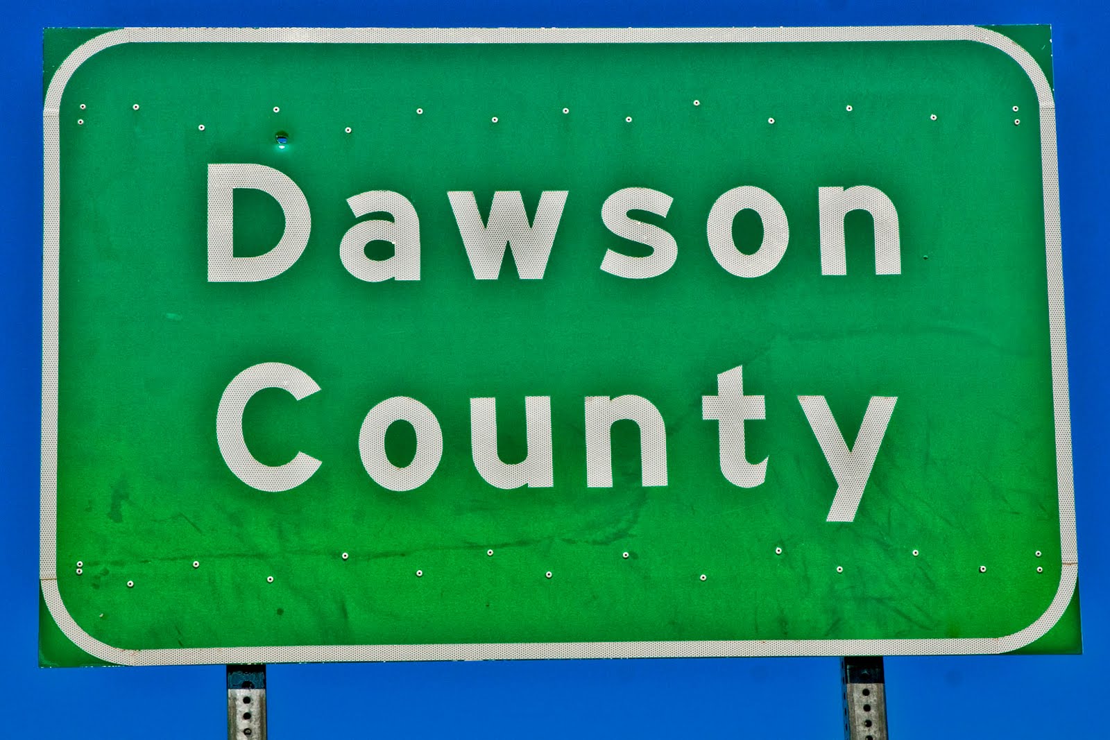
On what can only be described as a bit of Montana trivia, I have now photographed road signs indicating county boundaries for each of Montana's fifty-six counties. All use only upper case letters with one exception--Dawson County, as seen above.
 All that's left of a once-thriving community
Lindsay, Montana
Photo Information:
Glendive also served as a rail hub for the Northern Pacific railway, and a handsome station still stands in the downtown area. In 1920, some 500 men worked for the railroad in town. Today, rail transportation accounts for 13% of the county's wealth, second only to agriculture, but it employs only four percent of the male population. Farmers and farm managers make up 13% of male workers, while electrical equipment mechanics and other installation, maintenance, and repair occupations account for 8% of male employment. Not surprisingly, women's occupations are primarily in health care, and secondarily secretarial, education, cleaning and maintenance and record keeping. Unemployment, as of April 2010, was 4.2%, half the state-wide rate. Sixty-seven percent of wage or salary earners are employed in the private sector, and only 20% have government jobs. Twelve percent are self-employed. These figures come from the city-data.com website, which has a wealth of information.
 Makoshika State Park--Montana's largest
Covering 11,400 acres, Makoshika (ma-KO-shi-ka) State Park is the largest in Montana. It sits on the eastern edge of the city of Glendive, which allows that city's residents to claim that they are "Good People surrounded by Badlands." (Makoshika means "land of bad spirits," or badlands, in the Lakota language.) In addition to the Visitor's Center and Museum, the park also offers an amphitheater, a rifle range, archery range, group use shelter, campgrounds and even a disk golf course--all open to the public. The park has four miles of paved roads, approximately twelve miles of unpaved roads, and three hiking trails. Off-trail hiking is permitted in the park as well.
 Dawson County Rangeland
Looking north from Interstate 94
Agriculture has always been important in this region, and even today cattle ranches still cover large tracts of land. Barley, oats, corn (maize) and wheat all grow profusely in the rich soil of the county's rolling hills. If you drive the back roads, you'll pass mile upon mile of rangeland covered with cattle grazing, or seemingly endless acres of wheat fields. Again quoting from the city-data.com website, the average size farm in Dawson County covers 2,703 acres, or 4.22 square miles, and on average, each farm brings in $69,247 annually at an average expense of $62,382. Not a lot of profit there. Over 75% of the farms are operated by an individual or family, and the average age of the principal farm operator is 55. If that doesn't worry you, it should. Only 6.69% of all farmland in the county is irrigated, with 1331 harvested acres planted in corn and 164,040 in wheat. The value of livestock, poultry and their products accounts for 46.17% of total agricultural market value.
Glendive is also home to one of Montana's two-year colleges, Dawson Community College, which offers Associate of Applied Science degrees in Agribusiness Technology, Agricultural Mechanics, Business Management, Criminal Justice, Early Childhood Education, Engineering Technology, Gas and Diesel Technology, and even Music Technology, by which they mean training toward careers in the following fields, among others: "sound engineer, recording engineer, audio engineer, sound/video editor, multimedia publisher, radio program director, disc jockey, engineer mixer." Dawson Community College offers Associate of Arts degrees in a variety of fields, on-going Adult Education, and on-line learning possibilities, as well as providing educational outreach opportunities across eastern Montana.
If, like me, you enjoy a good Sunday drive, Dawson County offers plenty of opportunities to get out and explore. Aside from Makoshika State Park's paved and unpaved roads, you can drive Interstate 94 east to Wibaux County (52), or southwest to Prairie County (45), Montana 16 north along the Yellowstone River to Richland County (27), or Montana 200S northwest to McCone County (41). Along the way to Circle in McCone County, you'll pass through Lindsay, an up and coming agricultural community in 1920, now reduced to a pair of elevators and a few buildings. You also have a plethora of choices should you find the dirt back roads intriguing.
On what can only be described as a bit of Montana trivia, I have now photographed road signs indicating county boundaries for each of Montana's fifty-six counties. All use only upper case letters with one exception--Dawson County, as seen above.
 All that's left of a once-thriving community
Lindsay, Montana
All photos were taken using a Nikon D80 DSLR, a Nikkor 16-85 wide angle/tele/zoom lens, and were shot in RAW format and processed using Photoshop CS4.
Dawson County Sign: Taken 8/26/2011 at the Dawson/Wibaux County Line on US Interstate 94, west bound. Focal length: 62 mm. ISO 200, f /11.0, 1/500 second.
Dawson County Courthouse: Taken 10/7/2009 in Glendive, Montana. Focal length: 16 mm. ISO 250, f /22.0, 1/125 second.
Dawson County Rangeland: Taken 8/26/2011 on US Interstate 94, west bound. Focal length: 85 mm. ISO 200, f /11.0, 1/250 second.
Makoshika State Park: Taken 8/26/2011 in Glendive, Montana. Focal length: 85 mm. ISO 200, f /11.0, 1/350 second.
Lindsay Elevators: Taken 8/26/2011 in Lindsay, Montana. Focal length: 80 mm. ISO 200, f /11.0, 1/250 second.
No comments:
Post a Comment