Sunday, January 25, 2015

44. Wheatland County


Would it surprise you to learn that the principal industry in Wheatland County is agriculture, and that wheat itself is an important crop, with over 37,000 acres of land devoted to raising that particular grain?  Located just south of the geographic center of Montana, Wheatland County was created on February 22, 1917 with land taken from Meagher County (# 47) which lies to the west and Sweet Grass County (# 40) which lies to the south.  Almost square in shape, the county covers 1,428 square miles and as of the 2013 Census estimate, 2,134 people called it home.  In 1920, by comparison, the U.S. Census counted 5,619 people living within the county, a number that has never been equaled since.  In fact, each successive enumeration has shown fewer people living in the county than the preceding count, with the single exception of the 2000 Census which showed an increase of 0.6% over the 1990 Census.

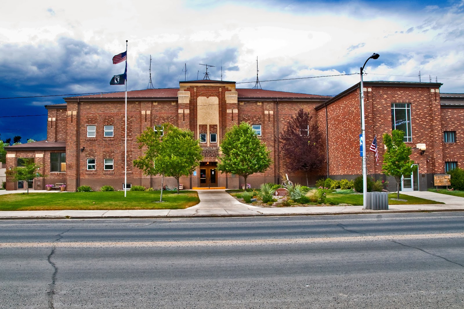
The Wheatland County Court House
Harlowton, Montana
September 8th, 2007

At the crossroads of US Highway 12 and US Highway 191, Harlowton is the only city in the county, and serves as the County Seat.  From its origin in 1900 as a stop on the Montana Railroad, up until 1974 when the Chicago, Milwaukee, St. Paul and Pacific (The Milwaukee Road) ceased operations, Harlo (as it's affectionately known) was a rail town.  It was even named for the President and founder of the Montana Railroad, Richard A. Harlow.  Harlow's original idea was to connect the Northern Pacific line at Lombard (Broadwater County, # 43) to the mining camps in the Castle Mountains of Meagher County (# 47), but by the time the track was laid, the mines were all but played out.  Harlow decided to continue the line to Lewistown in Fergus County (#8) and followed the Musselshell River to a point where the track turned north.  At that "turning point" the town he named for himself was born.

In 1908, the Montana Railroad became part of the western expansion of the Milwaukee Road.  Eventually, the Milwaukee reached Seattle, Bellingham, Washington, and even the Olympic Peninsula in western Washington State.  By 1914 the difficulties of running steam engines through the mountains of western Montana led to the decision to electrify the line--at least from Harlowton on to Avery, Idaho.  Harlo was the switching point where the new electric locomotives were put on the west bound trains and taken off those east bound.  It's much too much of a simplification to say that the Arab Oil Embargo of the early 1970s did in the Milwaukee.  The railroad had plenty of problems of its own causing.  But the sad fact is that the company made the decision to end electrified rail service in 1974, and then had to deal with the increased cost of diesel fuel, not to mention the cost of replacing all their electric stock.  By 1980, all Milwaukee operations west of Miles City, Montana ceased.  Today it is remembered in Montana by its beautiful stations, and by displays in Harlowton and Deer Lodge of the last of the electric locomotives.

Welcome to Harlowton
Electric Locomotive on display at the Welcome Park
September 8th, 2007

Harlo's business district was destroyed by a fire in 1907.  Twenty-four buildings, including the only hotel in town, were lost.  Local businessman A.C. Graves built a new hotel, but located it on the bluff above the railway station, and built it from locally quarried sandstone.  The Graves Hotel opened in 1909 with forty-five rooms, a restaurant and lobby, and a veranda on the second floor.  The loss of the Milwaukee cost Harlowton dearly, and the Graves Hotel felt that loss as well.  The largest privately owned building in the community, it stood sentinel on its hilltop,   There are reports that the hotel is haunted, but new owners are determined to restore the place, including its restaurant and coffee shop, and they look to reopen the hotel as a bed and breakfast.  They have put together a very colorful (in every sense of the word) website which includes a page of beautiful photographs of the Wheatland County landscape.


The Graves Hotel
Harlowton, Montana
July 30th, 2011

The Harlowton Women's Club has put together a county history which is included in the online Montana Memory Project.  Yesteryears and Pioneers contains over four hundred pages of Wheatland County memories, including stories of ten different communities, most of which today are mere memories themselves.  Apparently the oldest community in the county is Shawmut, located on U.S. Highway 12 in the southeastern corner of the county.  The post office in Shawmut dates from 1885 according to US Post Office records, and was run by a Mr. Francis Shaw, originally from Boston, Massachusetts.  The Shawmut Peninsula is where Boston's first streets were laid, and the name figures prominently in Boston history.  Shawmut, Montana, on the other hand, isn't even an incorporated town, and in 2010, the Census counted 42 people as residents.  Yesteryears and Pioneers, however, gives quite a history for this community which at one point boasted a hotel, a school, a bank, several shops, saloons (of course, this is Montana), a barber shop, restaurant, etc.  Today, Shawmut is probably best known as the community nearest to Deadman's Basin, a 1900 acre reservoir that draws fishermen from all over central Montana.

At the northern end of the county, along U.S. Highway 191, lies the town of Judith Gap.  Located at the low point between the Big Snowy Mountains and the Little Belt Mountains, the area has been traveled for centuries as the pass permitted movement between the southern part of the state and the central section.  With 126 residents as of the 2010 Census, Judith Gap is more than just a wide spot on the road.  The community itself grew with the coming of the railroad.  Seven saloons, a hotel, a bank, and all the various shops supported a community of 1,000 people.  The Great Northern Railway built a roundhouse and repair shop in the town, employing 250 folk in the early part of the twentieth century.  Grain elevators became the dominant buildings on the skyline as the area shipped wheat to market.  Surprisingly, the town had Montana's first cheese factory--not that it lasted very long, and also a cigar factory.

The Musselshell River
Two Dot, Montana
July 30th, 2011

Perhaps the most iconic of Montana's towns is located on the western end of the county, near the Meagher County line.  Two Dot got its name from the cattle brand used by the rancher who donated the land for the town.  The first post master was commissioned in 1900, and the town grew up around the railyard.  But make no mistake, Two Dot was and is a cattle town.  And just in case you're working on it, number 96 on the Great Falls Tribune's "A Montana Bucket List" is "Stop for a burger at the Two Dot Bar."

Sunday, January 18, 2015

43. Broadwater County

Growing up, I always thought that Broadwater County was named for the wide expanse of the Missouri River as it pools behind the Canyon Ferry Dam.  Driving east from Helena on US Highway 12, you quickly cross a corner of Jefferson County, then enter Broadwater County as you drive along the shore line of Canyon Ferry Lake.  The third largest body of water in Montana (after Flathead Lake and the Fort Peck Reservoir, also on the Missouri), most of Canyon Ferry Reservoir lies within the boundaries of Broadwater County.  But since the dam that forms the reservoir was only completed in 1954, and the county dates from 1897, my adult mind tells me that there has to be a different rationale for the county's name, and indeed there is.

The Montana Legislature took land from two of the state's original counties, Jefferson (# 51) and Meagher (# 47) to create Broadwater County on February 9, 1897, naming the county for Charles Arthur Broadwater, one of early Montana's most influential men.  Broadwater, like most early Montanans, was born out of state (St. Charles, Missouri), but built his fortune and lived most of his life in the Treasure State.  Cattle, transportation, real estate, banking, Broadwater had his hand in all of these.  He was also responsible for building one of the grandest structures ever seen in Montana, the Hotel Broadwater and Natatorium, just west of Helena.

The U.S. Census showed 5,612 Broadwater County residents in 2010, the largest population in the county's history.  This represents a 28% increase from the 2000 census, which itself showed a 32.2% increase over 1990.  In fact, the lowest count for the county came in 1970, with 2,526 residents, the only time the population was lower than at the time the county was first created.  Located between the Big Belt Mountains to the north and east, and the Elkhorn Mountains to the south and west, Broadwater County covers 1,239 square miles, and has a population density of 4.7 people per square mile.

The Broadwater County Courthouse
Townsend, Montana
July 30th, 2011

Almost perfectly located in the center of the county, Townsend is the seat.  When the Northern Pacific Railroad came through the area in 1883, the railroad named the town for the wife of a former president of the company.  The station was built to service the gold mines in the area, and the town grew up around the new commercial center.  With a 2012 estimated population of 1,970, Townsend would not be considered a city in most U.S. states, but this is, after all, Montana.  Townsend is the first city you come to following the Missouri River downstream from its source near Three Forks, and thus the city calls itself "The First City on the Missouri."  It is the only incorporated city in the county, although there are numerous other communities, including one, Canton, that is now completely submerged under the waters of the Missouri.  Today, Townsend is a thriving commercial center, servicing the needs of the many prosperous farms in Broadwater County, and welcoming those who come for the many recreational opportunities offered by Canyon Ferry, the Missouri River, and the mountains that ring the area.  Montana Magazine, many years ago, wrote up an Italian restaurant located in Townsend.  I ate at that restaurant many times (although at this point I have forgotten the name), and at one point I asked the owner/chef why he had left New York City for Townsend, Montana.  His answer was classic.  "I like to fish, and here I can get away any time I want and be on the water."  Either he has since retired, or he decided he needed to make a better living, as the restaurant is long gone.


The Broad Waters of Canyon Ferry Reservoir
North East of Winston, Montana
(Scanned from a photographic print)

South of Townsend, off a county road and far from any federal highway, lies the community of Radersburg.  One of the earliest of Montana towns, Radersburg got its start thanks to gold.  By 1869, five years after the creation of Montana Territory, the town had a population of 1,000.  Located in one of Montana's original nine counties, the town was chosen to be the seat of Jefferson County, and its namesake, Ruben Rader, was one of the first county commissioners for that county.  Elsie Ralls has written a great history of the community which shows up on the website of the Broadwater County Museum.  She tells how the community thrived and shriveled as gold rose and fell in value.  She points out that the fall in gold prices led Jefferson County to move the seat back to its original location in Boulder.  That happened in 1884, and in what might be considered kicking a town when it's down, the railroad came through at the same time and completely bypassed the community.  Many Radersburg folk moved to Townsend at that point.  But unlike so many other once thriving mining camps, Radersburg is not a ghost town.  According to the 2010 census, 66 people still call it home.

Almost due east of Radersburg, just off U.S. Highway 287 on the banks of the Missouri, sits the community of Toston.  Named for early settler Thomas Toston, the community got a post office in 1882.  The post office is still operating there, but the Methodist Church, which used to be served by the Townsend minister, apparently has closed.  The 2010 Census counted 108 people in Toston, so it's larger than Radersburg, but still a very small town by any definition.  Six miles upstream from the town is Toston Dam, the closest dam on the Missouri to that river's headwaters.  Toston Dam was built in the late 1930s (actually completed in 1940) and was the second most expensive dam of its kind to be built in Montana at that time.  It is a "run-of-the-river" hydroelectric dam which means that it doesn't rely on a reservoir to generate electricity.

Clouds above the Big Belt Mountains
Northern Broadwater County
September 8th, 2007

What I have found most surprising about Broadwater County is the number of new developments that have sprung up, either as bedroom communities for the state capitol in Helena, or for the tech center of the state in Bozeman.  The Silos, for example, was always one of the most recognizable features of the drive along Canyon Ferry.  Two large brick silos, uncapped as far back as I remember, stand sentinel between US Highway 12 and the lake shore.  There has long been a Bureau of Reclamation campground there, which today is joined by a KOA with a marina in Broadwater Bay.  But according to Wikipedia, there is a Census Designated Place there as well, with a 2010 population of 506.  This would make an area that I think of as campgrounds, the third largest community in the county.  Wheatland, another Census Designated Place, takes in the entire southern triangle of Broadwater County, and the 2010 Census counted 568 residents, making it second only to Townsend as a population center for the county.  I recall seeing beautiful large homes sprouting up on the hills above US 287 and Interstate 90 in this region, and I wondered why, but it has to be the lure of Bozeman, without the city congestion.  Wheatland is also the home of WheatMontana which claims Three Forks in neighboring Gallatin County (# 6) for a mailing address, but their location is definitely on the Broadwater County side of the line.  Wikipedia also claims the Spokane Creek Census Designated Place as a Broadwater County community.  Located at the point where Broadwater, Jefferson and Lewis and Clark (# 5) Counties all converge, Spokane Creek is a housing development with homes priced in the millions. There must be money in government service as this can only be a bedroom community for Helena.

Old Ranch in the Wheatland Area
Southern Broadwater County
April 28th, 2012

Sunday, January 11, 2015

42. Carter County


The southeastern corner of Montana is where you'll find Carter County.  Formed in 1917 with land taken from the southern portion of newly formed Fallon County (# 39), Carter County was named for Senator Thomas H. Carter, the first U.S. Representative from the State of Montana (1889-1891) and later two term Senator (1895-1901 and 1905-1911).  The county covers 3,348 square miles and as of the 2010 U.S. Census, 1.160 people called it home, giving it a population density of .3 people per square mile.  The 2013 census estimate revised the count upward by fourteen, the first increase in population the county has shown since 1930 when, at its height, the county boasted 4,136 residents.

The story goes that Claude Carter (and I haven't been able to establish any relationship between Claude and Thomas H.) was driving a wagon load of logs into Montana Territory, and bogged down in a creek.  In order to get his wagon out of the muck, he had to unload the logs.  While he probably used plenty of expletives in the process, he allegedly said, "Any place in Montana is good enough to build a saloon," and that's what he did.  In time, other businesses grew up around his saloon and the location was called Puptown.  When in 1885, the town's post office was created, the Postal Service assigned it the name Ekalaka, after the wife of a prominent local resident, Ijkalaka Russell.  Ijkalaka was an Oglala Sioux woman, and her husband, David Russell was a scout who settled in the area near Carter's saloon, becoming one of the first homesteaders in the region.


The Carter County Court House
Ekalaka, Montana

When Fallon County was created in 1913, Ekalaka was chosen over Baker to be county seat.  With the creation of Carter County, Ekalaka, the only town of any size in the new county, took the honor again.   The white clapboard two-story court house was built in 1920.  It's a pretty building that I found almost impossible to photograph.  For one thing, it faces north, so you're always shooting into the sun under good conditions.  For another, the grounds are beautifully landscaped with large trees hiding most of the structure, as you can see in my photograph above.  The Missoulian, Lee Enterprises' newspaper for western Montana, recently did an extensive story on Ekalaka as part of their Montana A to Z series.  E is for, what else, Ekalaka.  The writer spent a lot of time with the Church of Hank Williams, a social group that meets in the garage of Ekalaka resident Duane McCord.  Number one in their collection of twenty photographs of the area is of Montana Highway 7 looking north from town.  Until recently, Highway 7 was the only paved highway leading to Ekalaka, and it ends right before the court house.  No one drove to Ekalaka by accident (except, apparently, Claude Carter).  Today, a paved road connects the town to the only other "town" of any size in the county, Alzada  (2010 census count 29).

Founded in 1936, the Carter County Museum is the oldest county museum in the State of Montana.  Located in downtown Ekalaka, it is definitely worth a visit.  One more stop on the Montana Dinosaur Trail, the Museum has many paleontological exhibits, including a 6'6" tricerotops skull and a complete skeleton of an Anatotitan copei.  That's duck-billed dinosaur to the rest of us--one of only five discovered to date in the US.  Of course 75 million years ago, they ruled southeastern Montana.  The Museum also has geological, natural history, and early settlers (including Native American) exhibits.

Driving down Montana Highway 7 toward town
Ekalaka, Montana

Eleven miles north of Ekalaka is one of the most fascinating landscapes in the state.  Medicine Rocks has an interesting history as a state park.  Originally land sacred to the Sioux nation who lived in the area, the "rocks" became part of a working cattle ranch in the 1880s.  Carter County seized the land for back taxes during the dust bowl years of the 1930s, and turned 330 acres over to the State of Montana in 1957.  The State has lost several battles with the people of Carter County in the years since.  In 1991, for example, the State tried to close the park at night, but the people wouldn't have it.  Then again in 1991, the state imposed a $3 entrance fee, which the locals successfully fought.  The State responded by declaring the park "Primitive," which meant the State didn't have to do any maintenance.  In the end, we all won as Montana license plates now have an opt-out State Parks fee included in the cost of our plates, and any Montanan has free access to any state park simply by being in a car that is so licensed.  (And since it's an opt-out fee, most people don't bother.)  An early white visitor to the region declared it to be "as fantastically beautiful a place as I have ever seen."  That visitor later got, among other things, a Montana county named for him, a Nobel Peace Prize, and the Presidency of the United States.  Yep, you know him as Teddy Roosevelt.  Today there are picnic tables, twelve camp sites, and many, many rock formations to explore.  Just please, don't carve your initials in the sandstone.

One of the sandstone formation in the park
Medicine Rocks State Park

U.S. Highway 212 cuts across the southern edge of Carter County, and is probably the only way most non-locals see any of the county.  Long-haul truckers and I use the road as a short cut from Hardin, Montana, to Belle Fourche, South Dakota, and eventually the Black Hills.  You leave Interstate 90 at Crow Agency, south of Hardin, and return to Interstate 90 west of Spearfish, South Dakota.  In the meantime, you cross through the Crow Reservation, the Northern Cheyenne Reservation, and Powder River County (# 9) before entering Carter County near the unincorporated community of Boyes.  I can't say that I remember Boyes, even though I've driven the highway many times.  Roberta Carkeek Chaney, in her book Names on the Face of Montana has this to say about the community:
BOYES is a roadside store, gas station, and post office in the southern part of Carter County.  It was named for a Mr. Boyes, a resident of the area.  The post office was established in 1910.
Visit Montana has a bit more to say about the place, including Mr. Boyes' first name, Henry, and dates the post office from 1906.  Nowhere have I been able to find a population for the community.  And if you want to send them a note, the zip code for Boyes is 59316.  Six miles further down the road you'll pass Hammond, "a cluster of cabins and a general store," again according to Chaney.  I can't say I remember anything about Hammond either, and Visit Montana doesn't give us any more information.  Finally, just before you leave Montana and cross into northeastern Wyoming, you'll go through the town of Alzada.  Alzada I do remember, although with a population of 29, there's not much to note there other than the Sinclair Station on the north side of the highway and the Stoneyville Saloon on the south side.  The saloon proudly offers "Cheap Drinks" and "Lousy Food."  Don't ask me, they put it on their sign.  Alzada was originally named Stoneyville, but when they got their post office, it turned out that there was already a Stoneyville, Montana, so the town was renamed for the wife of one of the residents.  You can turn north at Alzada and follow Montana Highway 323 for seventy-one miles to get back to Ekalaka--a long way to go to pay your taxes or license your truck.  If you turn south, on the other hand, onto Montana 326, you're less than two miles from Wyoming, and only 41 miles from Devil's Tower.  But if you do that, you're definitely leaving Montana.

Wyoming State Line on US 212
Southeast of Alzada, Montana


Sunday, January 4, 2015

41. McCone County


McCone County, Montana, is a place I would venture to say even most Montanans have never visited.  No federal highway crosses the county, although Montana Highway 200 does serve the area, and even forks just east of the county seat of Circle into 200 and 200S, the former heading on to Fairview and the North Dakota state line and the latter turning south toward Glendive in neighboring Dawson County (#16).  The Montana State Legislature established McCone County in 1919 from land taken from Dawson (#16) and Richland (#27) counties, both of which now border McCone on the east.  They named the county for state senator George McCone who was instrumental in the creation of the new jurisdiction.  There is a fascinating biography of McCone included in H. Norman Hyatt's book A Hard Won Life available as an e-book here.  The county covers 2,683 square miles and as of the 2013 estimate, 1,709 people call it home, for a population density of .7 people per square mile.  This is the fewest number of people counted in the county's history, down from a high of 4,790 in 1930.  Every census since then has shown a substantial decrease with the single exception of 1960.

The only incorporated city in the county serves as county seat.  Circle is one of those Montana towns named for a cattle brand.  According to the historic point sign, in 1883 (or thereabouts), a Confederate Army veteran, Major Seth Mabrey, drove a herd of longhorn cattle up from Texas.  He branded his cattle with a simple circle design, and the ranch he founded became known as the Circle Ranch.  In time, the ranch spawned a saloon, and the saloon brought business (and drinkers).  The town that grew up around the saloon got the name from the ranch.  Today, those ubiquitous flags seen flying from lightposts all over the country say this, should you read them in town:  Circle, Montana  A Great Place to Be Around.  In 1919, Circle had some competition for the title of county seat.  Brockway, thirteen miles east along Montana 200 was in the running.  Circle won.  The 2010 Census counted 644 people living in Circle, roughly 38% of the county's population.

McCone County Court House
Circle, Montana

Circle is a pretty, little town, not unlike many other eastern Montana communities, but today it is the only town of any size in the county.  This has not always been the case.   As noted above, in 1919 Brockway gave Circle a run for its money in the race to become county seat.  These days, there's not much left of Brockway, but in the not too distant past, the community was a major shipping point on the Great Northern's branch line.  According to the book As It Was Yesterday,   as recently as 1963, more than a million bushels of wheat were shipped out of the Brockway station.  (It strikes me that that was over fifty years ago, now.)  Bob Fletcher, who wrote the text for all the original Montana Historic Marker signs said that Brockway "became a major livestock shipping point, reaching number one in the U.S. in 1934."  In 1910, James Brockway and his two brothers laid out a townsite, and soon there was a grocery store, a hardware store, a hotel, and the first high school in the county.  (The high school's last class graduated in 1943.)  As It Was Yesterday lists some twenty businesses located in Brockway over the years, including a bank, a creamery and a flour mill.  For thirteen years there was even a drive-in theater that closed in 1963.  Brockway has an "official" web site, but the most recent event listed there happened back in 2012, and most of the links on that site are broken.  One link that still works, takes you to the Brockway Mercantile's site, where you learn that you don't even have to visit Brockway to shop at the Brockway Mercantile.  The owner is a registered e-Bay seller.  The most recent population count I can find for Brockway comes from the 2000 census when 140 people called the Brockway area home. From Brockway south to the Prairie County (#45) line, the landscape is rolling, semi-arid land, suitable for dry-land farming and livestock.

Farmland in Southern McCone County

Vida is the only other town still extant in McCone County, with a 2000 census count of 70.  Vida is actually made up of two separate communities, Vida and Presserville, which merged in 1951.  According to Wikipedia, Vida today has an elementary school, a post office, a convenience store and gas station, and two churches.  Seeing as how none of the links on the Wikipedia site work, I won't vouch for the accuracy of their description, and sad to say, even though I drove through Vida on my travels around the state, I found nothing noteworthy there.  I'm sure I missed something.

To illustrate the fever and disappointments of the homesteading era, we need look no further than to the list of post offices on page 430 of As It Was Yesterday.  Fourteen area post offices make the list, opening as early as 1903 (Hedstrom) with all but Brockway now closed.  Some were only open a short time (one year or less), many closed in the 1930s as the homesteads dried up and blew away in the dust bowl.  Watkins stayed open until 1959, but Paris, and yes, there was a Paris, Montana, closed in 1937.  There's a picture of the Paris Post Office in the book on page 431.

The Lewis and Clark Bridge over the Missouri River
AKA The Wolf Point Bridge
(note my Volvo trying to hide in the lower left corner)


Montana Highway 200 is the only east-west highway to cross McCone County, but two Montana state highways run north-south.  Montana 13 runs north from Circle to the Canadian border at the Port of Scobey, passing through Wolf Point (Roosevelt County #17) and Scobey (Daniels County #37).  Where it crosses the Missouri River, it connects McCone County with Roosevelt County.  One of the county's two National Historical Registry sites is located here.  Since supplanted by a more modern highway bridge, the Lewis and Clark Bridge is the longest "and most massive through-truss" bridge in Montana.  Its 400 foot span is the longest in Montana, according to the Historical Marker sign at the location, which also notes that at its dedication on July 9, 1930,
The celebration included speeches, bands, a float, cowboys, and a daylight fireworks show.  The bridge was blessed by tribal elders from the Fort Peck Reservation.  A crowd of perhaps 15,000 people attended the festivities.
Along the western edge of the county, Montana Highway 24 runs from Highway 200 north to the Saskatchewan border at the Port of Opheim.  It crosses the Fort Peck dam on the Missouri, and passes through country lined with sandstone bluffs and other colorful geologic formations.  All in all, McCone County may well be out of the way, but still very much worth a visit.

Northeastern McCone County 
as seen from Montana Highway 24