Sunday, July 7, 2013

31. Teton County


Created in 1893, just four years into Montana’s statehood, Teton County took land from Missoula County (4) in the west and Chouteau County (19) in the east.  From the start, the county seat has been the town of Choteau.  (Note that in early day Montana, both the town of Choteau and the county of the same name were spelled without the “u.”  Choteau County became Chouteau County only in 1903.  Both are named for the French-American trapper and explorer, Pierre Chouteau, Jr., whose family helped found the city of St. Louis, Missouri and who were instrumental in helping Lewis and Clark set off on their Corps of Discovery Expedition. )  Originally Teton County stretched from its present southern boundary all the way to the Canadian border and included much of what is now Glacier National Park.  The creation of Toole County (21) in 1914 and then Pondera (26) and Glacier (38) Counties in 1919 reduced Teton County to its present size.  The loss of so much territory also meant a 38.5% reduction in population from the 1910 U.S. Census, and since 1920, the county’s population has remained relatively stable around 6,000 with a high of 7,295 recorded in the 1960 census.  The 2010 census counted 6,073 residents of whom 1,684 lived in Choteau. 


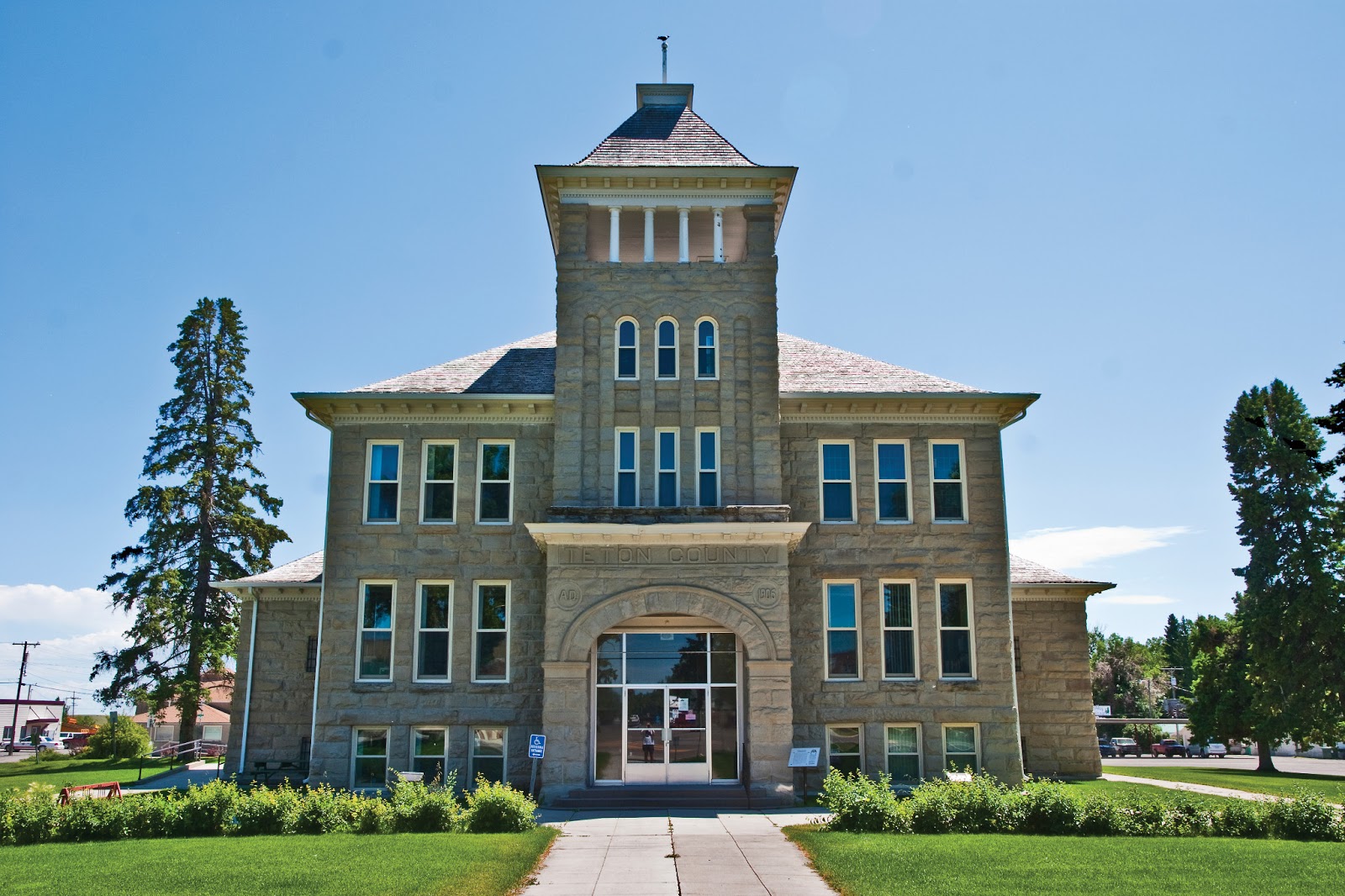
 The Teton County Courthouse, Choteau, Montana

The first European settlers in the Choteau area were Jesuit priests who built a mission there in 1859.  The mission lasted less than a year as the local natives were not at all receptive to the Jesuits' message.  In fact, they were downright hostile.  In 1868, the U.S. Government established an Agency for the Blackfeet Nation approximately three miles north of present day Choteau.  This remained operational for eleven years, and in 1875, a post office was built using the name Old Agency.  This is considered the predecessor of the town of Choteau, as the name was officially changed in 1882.  A.B. Guthrie, the man who gave Montana the nickname Big Sky Country, and author of numerous books about early Montana, owned a ranch just outside of Choteau.  If you stand in the hills of the Rocky Mountain Front (that place where the Great Plains meet the Rocky Mountains), you can easily see how Guthrie came up  with his titles, especially The Big Sky and These Thousand Hills.  Another famous resident, if only part-time, is TV host David Letterman, who bought a vacation ranch and married his wife at the Teton County Courthouse on March 19, 2009.  There are five other small towns within the county’s borders:  Bynum, Dutton, Fairfield, Pendroy and Power.  


The Rocky Mountain Front as seen from near Bynum, Montana 

None of these towns are very large.  Bynum, for example, had 47 residents in 2012.  But Bynum is home to the Two Medicine Dinosaur Center, a non-profit educational institute that opened in 1995.  Part of the Montana Dinosaur Trail, it is home to the first baby dinosaur bones collected in North America, a find made by Jack Horner at nearby Egg Mountain.  This discovery changed the way science viewed the ancient lizards, as it was the first example found that indicated dinosaurs actually acted like parents.  Horner, by the way, is not only one of the pre-eminent paleontologists of our era and Curator of Paleontology at the Museum of the Rockies at Montana State University, but he was the technical advisor for the Jurassic Park movies.  The Center is open seven days a week from Memorial Day through Labor Day, and has an irregular schedule during the rest of the year.  The Old Trail Museum in Choteau is also on the Montana Dinosaur Trail.

This is agricultural country, to be sure.  Fairfield, the second largest community in the county with a 2010 population of 708, is the "Malting Barley Capital of the World."  Montana is the fourth largest U.S. producer of barley, and a lot of it is grown around Fairfield, where nearly 140,000 acres are planted in barley.  Anheuser-Busch's Agricultural Resources is a major player in the local economy.  Fairfield is also home to Freezout Lake Wildlife Management Area, where some 300,000 snow geese visit every year.  Birders travel from all over to catch sight of these and other birds landing at Freezout.

 
Pelicans at Freezout Lake Wildlife Management Area 

The post office for Dutton (2010 population 310) was established in 1909.  A year later, the Choteau newspaper, the Choteau Acantha, had this to say about the new town:

The town of Dutton that lies directly east of Choteau in the eastern part of the county is one of the wonders of wonderful Montana. One year ago Dutton was nothing more than a whistling station on the G.N. while today it is a bustling little city of wide awake people. It is the outgrowth of the conditions that are produced by a fertile soil and the finest climate imaginable. Dutton is not an accident, but is on the map for the reason that it is needed.  It is the supply point for a large section of country extending for miles on either side. While there is not a depot as yet the G.N. stops their trains and receive freight and passengers. Since the opening of spring the receipts of freight have been large, especially building material. We are informed by N. Whitacre, the first lumber dealer in Dutton, that there has been over 50 cars received by the merchants and that he is now unloading his 32nd car. When you stop to think of this you will perceive that it figures up to a tidy sum. All of this goes to help build up the country and Teton Co. Dutton has three general stores, one hardware, one hotel, two rooming houses, one butcher shop, a real estate office, a racket store, two barber shops, four lumber yards. 
Dutton is the only town in Teton County on an Interstate Highway, I-15, which connects Los Angeles to the Canadian border. And no, I have no idea what a "racket store" is, but you have to love the enthusiasm of early day, small town newspapers.

The Rocky Mountain Front with Freezout Lake in the middle ground

The remaining two towns, Pendroy and Power are little more than wide spots in the road today.  Pendroy, north of Choteau, was the terminus for the Great Northern Railway's branch line that served Teton County, and Power, in the southeastern corner of the county, is right in the heart of Montana's Golden Triangle, an area known for its hard winter wheat.


Saturday, July 6, 2013

30. Deer Lodge County


Deer Lodge County is one of the oldest counties in Montana, having been formed by the Idaho Territorial Legislature on January 16, 1864.  Of the present Montana counties, only Missoula County is older, having been formed from the eastern part of Spokane County by the Washington Territorial Legislature in 1860.  With the creation of the Montana Territory, later in 1864, all the counties recognized by Idaho within the new territorial boundaries were accepted as Montana counties.  Over the next forty-three years, Deer Lodge County's lines changed repeatedly as Silver Bow (1), Granite (48), and Powell (28) Counties were formed in 1881, 1893 and 1901 respectively.  Other changes over the years involved boundary adjustments with other western Montana counties.  The loss of Powell County in 1901 almost brought about a change of name as well.  The Montana Legislature authorized the northern part of the county, now known as Powell County, to retain the Deer Lodge County name, and named the southern section Daly County, in honor of the copper king Marcus Daly, founder of the city of Anaconda.  For some reason, the name change never took place and today Powell County has as its seat the city of Deer Lodge, but Deer Lodge County has Anaconda for its seat.  Today Deer Lodge County is the second smallest county in Montana, covering 741 square miles (only Silver Bow County, #1, is smaller) and has a population of 9,298 according to the 2010 U.S. Census.  The county is one of two in Montana in which the city and county governments have consolidated.

 
The Deer Lodge County Courthouse
Anaconda  Montana
It is, I suppose, fitting that Deer Lodge County and the city of Anaconda should consolidate their governments.  The history of the city and its surrounding county are closely intertwined, and both tied to the fortunes of their neighbor to the southeast, Butte.  In 1883, copper king Marcus Daly filed for a town plat on farmland twenty-six miles northwest of Butte where he planned to build a smelter for the ore he was pulling out of "the richest hill on earth."  His chosen name for the town had already been used, so the Post Office suggested the name Anaconda.  The town and the smelter grew rapidly, and by 1910 there were over 10,000 residents in the city--almost all of whom worked either in the smelters or in the service industry serving those smelter workers.  One of the dirtiest election campaigns in Montana history occurred in 1894 when Daly tried to get his town chosen as the capital of the new state of Montana, then only five years old.  About the battle, historian Don Spritzer writes:

Many disliked both cities.  Helena, the temporary capital, was already entrenched in power and wealth. Anaconda was a "company" town owned largely by one man--Marcus Daly.  Yet everyone enjoyed the free drinks, cigars, and five-dollar bills dispensed by both sides in the weeks leading up to the election.  In the end all of Daly's money could not buy enough votes.  Helena prevailed by nearly 2,000 votes.*
  
The old Anaconda City Hall and Fire Station

I should note that at the time of the election, the seat of Deer Lodge County was the town of Deer Lodge, some twenty-five miles north and east of Anaconda.  In the aftermath of losing its bid, the people of Anaconda blamed the people of Deer Lodge for the loss (even though Deer Lodge residents had voted for Anaconda), and moved the seat to Anaconda.  My own take on the matter is that having lost the capital, the people of Anaconda erected a new "capital" building to serve as county court house.

Anaconda is one of those places I never tire of visiting.  I love walking the streets with my camera in hand, marveling at the historic architecture to be found throughout the city.  The old City Hall, shown above, is just one of hundreds of beautiful buildings to be found, not to mention the remnants of the Butte, Anaconda and Pacific Railway--the road Daly built to carry ore from Butte to Anaconda.  Having mentioned the railroad, I must add that if you saw the John Voight/Eric Roberts 1985 film "Runaway Train," the part of the Alaska Railroad was played by the BA&P.  My friend Catherine Dixon was a set painter on the film as well.  (If you haven't seen it, rent it from Netflix.)


Anaconda Smoke Stack State Park

Rising above a hill on the southeastern side of town, Montana's only inaccessible state park can be seen from twenty miles away.  The smoke stack from Daly's smelter was completed in 1919.  At the time, it was the largest free-standing masonry building in the world.  Even today it remains one of the tallest.  It is so tall (585 feet) with an inside diameter of 75 feet, that the Washington Monument would fit inside the stack with room to spare.  When ARCO (the Atlantic Richfield Company, owner of the Butte mines) closed the smelter in 1980, most of the facility's buildings were torn down.  The people of Anaconda asked that the stack be left as a memorial of the region's history, and the State of Montana took it over as a State Park, albeit one you can see only from a distance.  What you see in front of the stack in the picture above is just one of the piles of mining slag that cover hundreds of acres of ground around the town.

  Northeastern Deer Lodge County,
as seen from Interstate 90 near Warm Springs

The area between Anaconda and Butte is now part of an EPA Superfund cleanup site, and in the spirit of making lemonade from unwanted lemons, The Old Works Golf Course now stands on the grounds of the old Upper Works smelter which processed its first ore back in 1884.  Dormant for many years, the land was repurposed in 1994 when golf legend Jack Niklaus designed a world-class course for the site.  

But golf isn't your only option for recreation in Deer Lodge County.  One of my favorite cross-country ski areas is Mount Haggin, approximately fifteen miles southeast of Anaconda.  With deep powder, plenty of groomed sloping runs and almost perpetual blue sky, it's hard to beat a day on your skinny skis in Deer Lodge County.  If you prefer downhill skiing, Discovery Basin is just a few miles west of Anconda on the Deer Lodge/Granite County (46) line.  Discovery's runs look down on Georgetown Lake, a four season recreational area created in 1885 when Flint Creek was dammed to create electrical power.  The southern edge of Deer Lodge County follows the Big Hole River, a blue ribbon trout stream that draws anglers from all over the world.  The mines might be quiet and the smelters gone, but there's lots to do in today's Deer Lodge County.

*Spritzer, Don, Roadside History of Montana, Mountain Press Publishing, Missoula MT 1999, pp 218-219.